Please wait a minute...
img

官方微信

遥感技术与应用  2019, Vol. 34 Issue (2): 275-283    DOI: 10.11873/j.issn.1004-0323.2019.2.0275
模型与反演     
黄土高原土壤铁元素含量遥感反演方法
丁海宁1,2
(1.福州大学空间数据挖掘与信息共享教育部重点实验室,卫星空间信息技术综合应用国家地方联合工程研究中心,福建 福州 350116;
2.中国科学院遥感与数字地球研究所,北京 100094)
Remote Sensing Inversion Method of Soil Iron Content in the Loess Plateau
Ding Haining1,2,Chen Yu2,Chen Yunzhi 1
(1.Key Laboratory of Spatial Data Mining and Information Sharing of Ministry of Education,National & Local Joint Engineering Research Center of Satellite Geospatial Information Technology,Fuzhou University,Fuzhou 350116,China;
2.Institute of Remote Sensing and Digital Earth,Chinese Academy of Sciences,Beijing 100094,China)
 全文: PDF(5502 KB)  
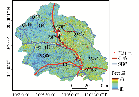
摘要: 利用光谱技术可快速而高效地获取土壤组分及其空间分布信息,为准确估算黄土高原土壤Fe元素含量与分布特征,通过对榆林东部地区的典型黄土进行野外采集、室内理化分析、光谱测定及其预处理,分析土壤铁含量与反射光谱的相关性,筛选敏感波段,利用偏最小二乘法建模,确定最佳估算模型。光谱反射率及其不同变换后筛选出的敏感波段,主要分布在500、870、1 700、2 200 nm附近;原始反射率(Ref)建模结果相对较稳定且预测效果最佳,预测集相关系数R2达0.73,均方根误差RMSEP最小;经导数变换(FDR和SDR)及连续统去除CR变换的模型次之,预测集R2分别达到0.61和0.64;采用波段内插法将土壤Fe含量最优估算模型Ref应用Sentinel-2多光谱遥感影像上,得到土壤Fe含量遥感反演图,结果表明研究区土壤Fe含量的分布特征与地层密切相关;该研究结果可为土壤Fe元素含量遥感分析提供支撑,实现黄土高原土壤铁的光谱快速制图。
关键词: 黄土高原高光谱铁元素偏最小二乘回归Sentinel-2遥感反演方法    
Abstract: The information of soil composition and its spatial distribution could be obtained quickly and efficiently by using spectral technology.In order to accurately estimate the content and distribution characteristics of soil Fe elements in the loess plateau,the typical loess in the eastern part of Yulin was collected in the field.Laboratory physical and chemical analysis,spectral determination and pretreatment,analysis of the correlation between soil iron content and reflection spectrum,screening sensitive bands,using partial least squares modeling to determine the best estimation model.The spectral reflectivity and the selected sensitive bands are mainly distributed at 500 nm,870 nm,1 700 nm and 2 200 nm.The original reflectivity(Ref) modeling results are relatively stable and the prediction effect is the best.The prediction set correlation coefficient R2 is up to 0.73 and the Root Mean Square Error(RMSEP) is the smallest.After derivative transform(FDR and SDR) and continuum removal of CR transform,the prediction set R2 is 0.61 and 0.64,respectively.The optimal estimation model of soil Fe content(Ref) was applied to the Sentinel-2 multi-spectral remote sensing image to obtain the remote sensing inversion map of soil Fe content by band interpolation.It was found that the distribution characteristics of soil Fe content in the studied area were closely related to the strata.The results of this study can provide support for remote sensing analysis of soil Fe element content and realize rapid spectral mapping of soil iron in the Loess Plateau.
Key words: Loess plateau    Hyperspectra    Iron element    Partial least square regression    Sentinel-2    Remote sensing inversion method
收稿日期: 2018-05-04 出版日期: 2019-05-10
ZTFLH:  TP79  
基金资助: 国家自然科学基金项目(41401488、41601383),国家重点研发计划课题(2017YFC1500902、2017YFB0504203)资助。
作者简介: 丁海宁(1993-),女,安徽淮南人,硕士研究生,主要从事土壤高光谱研究。 E-mail:dinghaining1005@163.com。
服务  
把本文推荐给朋友
加入引用管理器
E-mail Alert
RSS
作者相关文章  

引用本文:

丁海宁. 黄土高原土壤铁元素含量遥感反演方法 [J]. 遥感技术与应用, 2019, 34(2): 275-283.

Ding Haining, Chen Yu, Chen Yunzhi . Remote Sensing Inversion Method of Soil Iron Content in the Loess Plateau. Remote Sensing Technology and Application, 2019, 34(2): 275-283.

链接本文:

http://www.rsta.ac.cn/CN/10.11873/j.issn.1004-0323.2019.2.0275        http://www.rsta.ac.cn/CN/Y2019/V34/I2/275

[1] 左成欢,赵辽英,陆海强,厉小润. 由粗到细的高光谱图像多端元光谱混合分析[J]. 遥感技术与应用, 2019, 34(6): 1305-1314.
[2] 许宁,胡玉新,耿修瑞. 凸体几何光谱解混研究进展及若干问题浅析[J]. 遥感技术与应用, 2019, 34(5): 1028-1039.
[3] 贺军亮,崔军丽,张淑媛,李仁杰,查勇. 基于偏最小二乘的土壤重金属铜含量高光谱估算[J]. 遥感技术与应用, 2019, 34(5): 998-1004.
[4] 程雪,贺炳彦,黄耀欢,孙志刚,李鼎,朱婉雪. 基于无人机高光谱数据的玉米叶面积指数估算[J]. 遥感技术与应用, 2019, 34(4): 775-784.
[5] 周龙飞,张云鹤,成枢,顾晓鹤,杨贵军,孙乾,束美艳. 不同生育期倒伏胁迫下玉米叶面积指数高光谱响应解析[J]. 遥感技术与应用, 2019, 34(4): 766-774.
[6] 张晓光,姜子璇,孔繁昌. 滨海盐渍土可见近红外高光谱特征[J]. 遥感技术与应用, 2019, 34(4): 816-821.
[7] 王思恒, 黄长平, 张立福, 高显连, 付安民. 陆地生态系统碳监测卫星远红波段叶绿素荧光反演算法设计[J]. 遥感技术与应用, 2019, 34(3): 476-487.
[8] 梁丽娟, 黄万里张容焱, 林广发, 彭俊超, 梁春阳. Sentinel-2卫星影像融合方法与质量评价分析[J]. 遥感技术与应用, 2019, 34(3): 612-621.
[9] 李琼琼, 柳云龙. 城市居民区土壤重金属含量高光谱反演研究[J]. 遥感技术与应用, 2019, 34(3): 540-546.
[10] 林沂, 张萌丹, 张立福, 江淼. 高光谱激光雷达谱位合一的角度效应分析[J]. 遥感技术与应用, 2019, 34(2): 225-231.
[11] 张明月, 张奇栎, 王璐, 田尉霞, 王茂芝. 东北黑土区土壤铬含量高光谱反演研究[J]. 遥感技术与应用, 2019, 34(2): 313-322.
[12] 牟多铎, 刘磊. ELM与SVM在高光谱遥感图像监督分类中的比较研究[J]. 遥感技术与应用, 2019, 34(1): 115-124.
[13] 胡鹏飞, 李净, 张彦丽. 黄土高原水储量的时空变化及影响因素[J]. 遥感技术与应用, 2019, 34(1): 176-186.
[14] 皋厦, 申鑫, 代劲松, 曹林. 结合LiDAR单木分割和高光谱特征提取的城市森林树种分类[J]. 遥感技术与应用, 2018, 33(6): 1073-1083.
[15] 高书鹏, 史正涛, 刘晓龙, 柏延臣. 基于高时空分辨率可见光遥感数据的热带山地橡胶林识别[J]. 遥感技术与应用, 2018, 33(6): 1122-1131.