Synergy of active and passive remote sensing data for effective mapping of oil palm plantation in Malaysia
3
2020
... 油棕是一种高产的油料作物,其生产的棕榈油具有广泛用途,如生产食用油、工业润滑油、食品添加剂、生物燃料等,在世界油料市场占有重要地位[1-3].油棕主要种植在热带地区,其生长对温度、降水、海拔和坡度有较高的要求,一般种植在年平均温度22 ℃ 以上、年降雨量1 200 mm以上、海拔高度300 m以下及坡度小于10° 的地区[4].油棕最初只在非洲种植,但是自20世纪80年代以来,棕榈油的经济价值逐渐被开发,全球棕榈油需求量呈指数上升,导致在全球各地出现大规模的油棕种植园,截止2016年,全球油棕种植面积估计为29.29 Mha[5,6],主要集中在印度尼西亚、马来西亚、尼日利亚等国家,分布在东南亚、非洲和拉丁美洲地区.油棕种植园的快速扩张在带来经济效益的同时,也在不断侵占全球现有的森林、耕地和泥炭地,造成严重的生态环境问题,例如生物多样性丧失、生态系统失衡等[7-14].准确绘制油棕覆盖图,估算其面积、地上生物量、树龄、产量等,对研究油棕扩张对生态环境的影响以及实现可持续发展的油棕产业具有重要意义[15-20]. ...
... 了解油棕种植园的空间分布情况是油棕研究的基础,开展油棕制图研究的问题主要集中在大尺度制图和利用不同遥感数据与分类方法提高制图精度.现有的油棕制图研究往往追求在较大范围进行(一个国家、州或省等),比如Cheng等[18]、Najib等[1]、Dong等[36]对马来西亚进行了油棕制图研究.所使用的遥感数据以光学遥感数据(Landsat、SPOT(Systeme Probatoire d’Observation de la Terre)、QuickBird、Sentinel-2等)为主,越来越多的学者使用SAR数据(PALSAR、Sentinel-1、Radarsat等)来表现地表纹理特征,但是结果表明使用SAR数据的制图精度并不稳定[7, 18].也有部分学者使用MODIS(Moderate-resolution Imaging Spectroradiometer)数据进行制图,结果较为理想[37].在分类方法上,传统的最大似然分类方法仍然被广泛使用,但是结果精度欠佳[38, 39],基于机器学习的分类方法(RF(Random Forest)、SVM、ANN)越来越受关注,制图精度相较于传统分类方法也有较大提升[6, 40].Cheng等[6]利用MLC、RF和SVM对马来西亚进行油棕制图,结果表明RF(91.07%)和SVM(90.41%)比MLC(89.72%)具有更好的制图精度.油棕制图研究因为主要以识别油棕为主,所以分类系统主要围绕油棕,一般情况下以油棕和其他作为主要类别,但是很多研究都指出低龄油棕难以区分,会影响制图精度[41-43]. ...
... 目前,多源遥感数据的联合是油棕制图的重要方向,尤其是结合光学遥感数据和SAR数据进行油棕制图[1, 7, 18].结合遥感图像的光谱特征和纹理信息可以更容易地将油棕与周围地物区分开来,从而提高油棕制图的精度[60, 88]. ...
Annual oil palm plantation maps in Malaysia and Indonesia from 2001 to 2016
1
2020
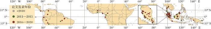
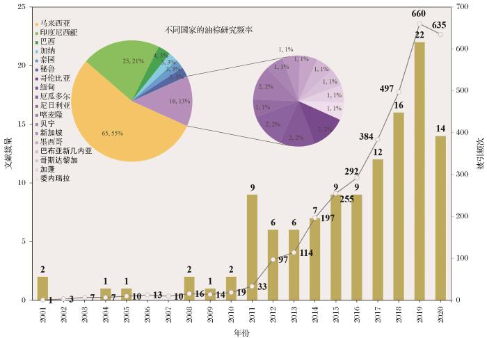
... 相关研究主要集中在东南亚、非洲和拉丁美洲的赤道附近国家(图1).大部分集中在东南亚地区,占到总量的82.3%,其中马来西亚和印度尼西亚分别占总量的54.6%和21.0%(图2),是油棕研究最为频繁的两个国家.目前,东南亚是全球油棕种植面积最大的地区[34],印度尼西亚和马来西亚更是全球油棕种植面积最大的两个国家,占到全球油棕面积的60%以上,并且在过去几十年一直保持着全球最快的油棕面积扩张速率[2,35]. ...
Large-scale oil palm tree detection from high-resolution satellite images using two-stage convolutional neural networks
2
2019
... 油棕是一种高产的油料作物,其生产的棕榈油具有广泛用途,如生产食用油、工业润滑油、食品添加剂、生物燃料等,在世界油料市场占有重要地位[1-3].油棕主要种植在热带地区,其生长对温度、降水、海拔和坡度有较高的要求,一般种植在年平均温度22 ℃ 以上、年降雨量1 200 mm以上、海拔高度300 m以下及坡度小于10° 的地区[4].油棕最初只在非洲种植,但是自20世纪80年代以来,棕榈油的经济价值逐渐被开发,全球棕榈油需求量呈指数上升,导致在全球各地出现大规模的油棕种植园,截止2016年,全球油棕种植面积估计为29.29 Mha[5,6],主要集中在印度尼西亚、马来西亚、尼日利亚等国家,分布在东南亚、非洲和拉丁美洲地区.油棕种植园的快速扩张在带来经济效益的同时,也在不断侵占全球现有的森林、耕地和泥炭地,造成严重的生态环境问题,例如生物多样性丧失、生态系统失衡等[7-14].准确绘制油棕覆盖图,估算其面积、地上生物量、树龄、产量等,对研究油棕扩张对生态环境的影响以及实现可持续发展的油棕产业具有重要意义[15-20]. ...
... 油棕树计数是对油棕种植园进行产量估算、种植园管理和空间布局规划的基础.因为其对遥感数据空间分辨率的高要求,未来无人机遥感数据将是油棕树计数的主要数据源.传统的油棕树计数会消耗大量的时间和人力,遥感提供了油棕树计数的新思路.基于遥感图像,通过图像处理和机器学习技术可以准确估算图像范围内的油棕树数量.与油棕制图不同,计数对遥感图像的空间分辨率要求较高.在现有研究中,多采用QuickBird、WorldView等达到米级或者亚米级空间分辨率的遥感数据[3, 49-51];越来越多的研究使用无人机遥感图像,因为无人机遥感图像不仅具有更高空间分辨率,而且数据的获取更具便捷性、实时性 [24, 52].从检测方法上看,多采用机器学习的方法,卷积神经网络(Convolutional Neural Network,CNN)使用最多,其次为支持向量机(SVM)和面向对象的图像分析(OBIA),都取得了比较理想的精度,但是存在区域上的差异.Zheng等[25]提出了一种新的跨区域油棕树检测方法(Multi-level Attention Domain Adaptation Network,MADAN),统计精度要优于现有的域适应方法,但是不能保证在更复杂、更大范围仍然适用. ...
Oil palm modelling in the global land-surface model ORCHIDEE-MICT
2
2021
... 油棕是一种高产的油料作物,其生产的棕榈油具有广泛用途,如生产食用油、工业润滑油、食品添加剂、生物燃料等,在世界油料市场占有重要地位[1-3].油棕主要种植在热带地区,其生长对温度、降水、海拔和坡度有较高的要求,一般种植在年平均温度22 ℃ 以上、年降雨量1 200 mm以上、海拔高度300 m以下及坡度小于10° 的地区[4].油棕最初只在非洲种植,但是自20世纪80年代以来,棕榈油的经济价值逐渐被开发,全球棕榈油需求量呈指数上升,导致在全球各地出现大规模的油棕种植园,截止2016年,全球油棕种植面积估计为29.29 Mha[5,6],主要集中在印度尼西亚、马来西亚、尼日利亚等国家,分布在东南亚、非洲和拉丁美洲地区.油棕种植园的快速扩张在带来经济效益的同时,也在不断侵占全球现有的森林、耕地和泥炭地,造成严重的生态环境问题,例如生物多样性丧失、生态系统失衡等[7-14].准确绘制油棕覆盖图,估算其面积、地上生物量、树龄、产量等,对研究油棕扩张对生态环境的影响以及实现可持续发展的油棕产业具有重要意义[15-20]. ...
... 准确估算油棕地上生物量和碳储量,是评估油棕在全球碳循环中作用的基础,对研究全球气候变化具有重要意义[17, 57, 58].虽然MODIS提供GPP产品,但是其对油棕生物量估算的精度欠佳[58].Morel等[35]利用ALOS-PALSAR数据估算马来西亚沙巴州的森林与油棕地上生物量,发现了区分森林和油棕的信号特征,证明该数据集用于监测油棕的潜力,但是SAR数据受环境状况的影响较大.Nunes等[59]开创性地利用激光雷达数据进行碳储量估计,结果显示基于面积的估算方法要优于以树为中心的估算方法,但是准确性仍然较低.多数研究是依据样地数据或者植被指数建立经验回归模型进行估算[35, 60],Foody等[61]尝试利用人工神经网络的方法进行估算,发现NDVI等植被指数与生物量相关性弱且不显著,认为应该充分利用遥感数据的所有波段进行估算.Fan等[62]和Xu等[4]在陆面模式中开发油棕生长模块,模拟油棕生长过程,为未来结合遥感观测数据估算大尺度油棕扩张造成的地上生物量与碳储量变化提供新的研究方法. ...
Towards global oil palm plantation mapping using remote-sensing data
4
2018
... 油棕是一种高产的油料作物,其生产的棕榈油具有广泛用途,如生产食用油、工业润滑油、食品添加剂、生物燃料等,在世界油料市场占有重要地位[1-3].油棕主要种植在热带地区,其生长对温度、降水、海拔和坡度有较高的要求,一般种植在年平均温度22 ℃ 以上、年降雨量1 200 mm以上、海拔高度300 m以下及坡度小于10° 的地区[4].油棕最初只在非洲种植,但是自20世纪80年代以来,棕榈油的经济价值逐渐被开发,全球棕榈油需求量呈指数上升,导致在全球各地出现大规模的油棕种植园,截止2016年,全球油棕种植面积估计为29.29 Mha[5,6],主要集中在印度尼西亚、马来西亚、尼日利亚等国家,分布在东南亚、非洲和拉丁美洲地区.油棕种植园的快速扩张在带来经济效益的同时,也在不断侵占全球现有的森林、耕地和泥炭地,造成严重的生态环境问题,例如生物多样性丧失、生态系统失衡等[7-14].准确绘制油棕覆盖图,估算其面积、地上生物量、树龄、产量等,对研究油棕扩张对生态环境的影响以及实现可持续发展的油棕产业具有重要意义[15-20]. ...
... 基于合成孔径雷达(SAR)数据,可以利用油棕种植园规则的种植形态使油棕与其他覆被类型相区别[5, 35, 84, 86, 87].SAR在对地观测上,相较于光学遥感具有明显的优势[39],已经有较多的学者采用了SAR数据,开展基于纹理特征的机器学习等方法的油棕制图研究[5, 39, 42, 84, 87],但是取得的精度并不理想.SAR数据在具有巨大优势的同时也存在着明显的不足,SAR数据波段较少而且影像信噪比低,这就使得SAR数据的油棕制图结果精度不稳定(图7). ...
... [5, 39, 42, 84, 87],但是取得的精度并不理想.SAR数据在具有巨大优势的同时也存在着明显的不足,SAR数据波段较少而且影像信噪比低,这就使得SAR数据的油棕制图结果精度不稳定(图7). ...
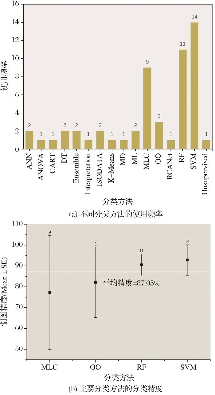
... 在油棕制图研究中,主要采用的分类方法是最大似然分类(MLC)、随机森林(RF)和支持向量机(SVM),而RF与SVM取得的精度更为理想(图8).计算机视觉技术和机器学习技术的蓬勃发展极大地促进了遥感图像识别及信息提取研究[89],并被越来越多地应用于油棕制图研究中[5, 6, 40, 87, 90]. ...
Mapping oil palm plantation expansion in malaysia over the past decade (2007-2016) Using ALOS-1/2 PALSAR-1/2 Data
4
2019
... 油棕是一种高产的油料作物,其生产的棕榈油具有广泛用途,如生产食用油、工业润滑油、食品添加剂、生物燃料等,在世界油料市场占有重要地位[1-3].油棕主要种植在热带地区,其生长对温度、降水、海拔和坡度有较高的要求,一般种植在年平均温度22 ℃ 以上、年降雨量1 200 mm以上、海拔高度300 m以下及坡度小于10° 的地区[4].油棕最初只在非洲种植,但是自20世纪80年代以来,棕榈油的经济价值逐渐被开发,全球棕榈油需求量呈指数上升,导致在全球各地出现大规模的油棕种植园,截止2016年,全球油棕种植面积估计为29.29 Mha[5,6],主要集中在印度尼西亚、马来西亚、尼日利亚等国家,分布在东南亚、非洲和拉丁美洲地区.油棕种植园的快速扩张在带来经济效益的同时,也在不断侵占全球现有的森林、耕地和泥炭地,造成严重的生态环境问题,例如生物多样性丧失、生态系统失衡等[7-14].准确绘制油棕覆盖图,估算其面积、地上生物量、树龄、产量等,对研究油棕扩张对生态环境的影响以及实现可持续发展的油棕产业具有重要意义[15-20]. ...
... 了解油棕种植园的空间分布情况是油棕研究的基础,开展油棕制图研究的问题主要集中在大尺度制图和利用不同遥感数据与分类方法提高制图精度.现有的油棕制图研究往往追求在较大范围进行(一个国家、州或省等),比如Cheng等[18]、Najib等[1]、Dong等[36]对马来西亚进行了油棕制图研究.所使用的遥感数据以光学遥感数据(Landsat、SPOT(Systeme Probatoire d’Observation de la Terre)、QuickBird、Sentinel-2等)为主,越来越多的学者使用SAR数据(PALSAR、Sentinel-1、Radarsat等)来表现地表纹理特征,但是结果表明使用SAR数据的制图精度并不稳定[7, 18].也有部分学者使用MODIS(Moderate-resolution Imaging Spectroradiometer)数据进行制图,结果较为理想[37].在分类方法上,传统的最大似然分类方法仍然被广泛使用,但是结果精度欠佳[38, 39],基于机器学习的分类方法(RF(Random Forest)、SVM、ANN)越来越受关注,制图精度相较于传统分类方法也有较大提升[6, 40].Cheng等[6]利用MLC、RF和SVM对马来西亚进行油棕制图,结果表明RF(91.07%)和SVM(90.41%)比MLC(89.72%)具有更好的制图精度.油棕制图研究因为主要以识别油棕为主,所以分类系统主要围绕油棕,一般情况下以油棕和其他作为主要类别,但是很多研究都指出低龄油棕难以区分,会影响制图精度[41-43]. ...
... [6]利用MLC、RF和SVM对马来西亚进行油棕制图,结果表明RF(91.07%)和SVM(90.41%)比MLC(89.72%)具有更好的制图精度.油棕制图研究因为主要以识别油棕为主,所以分类系统主要围绕油棕,一般情况下以油棕和其他作为主要类别,但是很多研究都指出低龄油棕难以区分,会影响制图精度[41-43]. ...
... 在油棕制图研究中,主要采用的分类方法是最大似然分类(MLC)、随机森林(RF)和支持向量机(SVM),而RF与SVM取得的精度更为理想(图8).计算机视觉技术和机器学习技术的蓬勃发展极大地促进了遥感图像识别及信息提取研究[89],并被越来越多地应用于油棕制图研究中[5, 6, 40, 87, 90]. ...
Combining radar and optical imagery to map oil palm plantations in Sumatra, Indonesia,using the Google Earth Engine
3
2020
... 油棕是一种高产的油料作物,其生产的棕榈油具有广泛用途,如生产食用油、工业润滑油、食品添加剂、生物燃料等,在世界油料市场占有重要地位[1-3].油棕主要种植在热带地区,其生长对温度、降水、海拔和坡度有较高的要求,一般种植在年平均温度22 ℃ 以上、年降雨量1 200 mm以上、海拔高度300 m以下及坡度小于10° 的地区[4].油棕最初只在非洲种植,但是自20世纪80年代以来,棕榈油的经济价值逐渐被开发,全球棕榈油需求量呈指数上升,导致在全球各地出现大规模的油棕种植园,截止2016年,全球油棕种植面积估计为29.29 Mha[5,6],主要集中在印度尼西亚、马来西亚、尼日利亚等国家,分布在东南亚、非洲和拉丁美洲地区.油棕种植园的快速扩张在带来经济效益的同时,也在不断侵占全球现有的森林、耕地和泥炭地,造成严重的生态环境问题,例如生物多样性丧失、生态系统失衡等[7-14].准确绘制油棕覆盖图,估算其面积、地上生物量、树龄、产量等,对研究油棕扩张对生态环境的影响以及实现可持续发展的油棕产业具有重要意义[15-20]. ...
... 了解油棕种植园的空间分布情况是油棕研究的基础,开展油棕制图研究的问题主要集中在大尺度制图和利用不同遥感数据与分类方法提高制图精度.现有的油棕制图研究往往追求在较大范围进行(一个国家、州或省等),比如Cheng等[18]、Najib等[1]、Dong等[36]对马来西亚进行了油棕制图研究.所使用的遥感数据以光学遥感数据(Landsat、SPOT(Systeme Probatoire d’Observation de la Terre)、QuickBird、Sentinel-2等)为主,越来越多的学者使用SAR数据(PALSAR、Sentinel-1、Radarsat等)来表现地表纹理特征,但是结果表明使用SAR数据的制图精度并不稳定[7, 18].也有部分学者使用MODIS(Moderate-resolution Imaging Spectroradiometer)数据进行制图,结果较为理想[37].在分类方法上,传统的最大似然分类方法仍然被广泛使用,但是结果精度欠佳[38, 39],基于机器学习的分类方法(RF(Random Forest)、SVM、ANN)越来越受关注,制图精度相较于传统分类方法也有较大提升[6, 40].Cheng等[6]利用MLC、RF和SVM对马来西亚进行油棕制图,结果表明RF(91.07%)和SVM(90.41%)比MLC(89.72%)具有更好的制图精度.油棕制图研究因为主要以识别油棕为主,所以分类系统主要围绕油棕,一般情况下以油棕和其他作为主要类别,但是很多研究都指出低龄油棕难以区分,会影响制图精度[41-43]. ...
... 目前,多源遥感数据的联合是油棕制图的重要方向,尤其是结合光学遥感数据和SAR数据进行油棕制图[1, 7, 18].结合遥感图像的光谱特征和纹理信息可以更容易地将油棕与周围地物区分开来,从而提高油棕制图的精度[60, 88]. ...
Consequences of tropical land use for multitrophic biodiversity and ecosystem functioning
0
2014
Reductions in emissions from deforestation from Indonesia's Moratorium on new oil palm, timber, and logging concessions
0
2015
Quantifying and understanding land cover changes by large and small oil palm expansion regimes in the Peruvian Amazon
1
2019
... 油棕的变化制图主要是为了研究油棕时空变化特征和驱动因素,监测油棕变化对其他土地覆被类型和生态环境的影响[44, 45],另外对未来油棕变化进行有效预测也十分重要.多个研究指出油棕扩张严重侵占了其他土地覆被类型,尤其是森林、农地、泥炭地等,对生态环境造成严重影响[10, 15, 46].油棕变化制图是在土地利用制图的基础上进行时间维度上的扩展,遥感数据的周期性使得开展逐年油棕变化制图成为可能.De Petris等[15]基于MODIS的增强植被指数(Enhanced Vegetation Index)数据估算了2000至2018年间中加里曼丹(Kalimantan Tengah)的油棕种植园扩张面积,取得了94%的总体精度.基于RS技术只能对过去的油棕变化进行检测,但是基于GIS技术利用时空模拟模型可以模拟未来土地覆被变化,为优化油棕和其他土地覆被类型的空间格局提供参考[47, 48],这为未来油棕研究提供了新思路. ...
Local surface temperature change due to expansion of oil palm plantation in Indonesia
0
2014
Can riparian forest buffers increase yields from oil palm plantations?
0
2018
Characterizing commercial oil palm expansion in Latin America: Land use change and trade
0
2017
Oil palm for biodiesel in Brazil-Risks and opportunities
1
2015
... 油棕是一种高产的油料作物,其生产的棕榈油具有广泛用途,如生产食用油、工业润滑油、食品添加剂、生物燃料等,在世界油料市场占有重要地位[1-3].油棕主要种植在热带地区,其生长对温度、降水、海拔和坡度有较高的要求,一般种植在年平均温度22 ℃ 以上、年降雨量1 200 mm以上、海拔高度300 m以下及坡度小于10° 的地区[4].油棕最初只在非洲种植,但是自20世纪80年代以来,棕榈油的经济价值逐渐被开发,全球棕榈油需求量呈指数上升,导致在全球各地出现大规模的油棕种植园,截止2016年,全球油棕种植面积估计为29.29 Mha[5,6],主要集中在印度尼西亚、马来西亚、尼日利亚等国家,分布在东南亚、非洲和拉丁美洲地区.油棕种植园的快速扩张在带来经济效益的同时,也在不断侵占全球现有的森林、耕地和泥炭地,造成严重的生态环境问题,例如生物多样性丧失、生态系统失衡等[7-14].准确绘制油棕覆盖图,估算其面积、地上生物量、树龄、产量等,对研究油棕扩张对生态环境的影响以及实现可持续发展的油棕产业具有重要意义[15-20]. ...
Detection and characterization of oil palm plantations through MODIS EVI time series
3
2019
... 油棕是一种高产的油料作物,其生产的棕榈油具有广泛用途,如生产食用油、工业润滑油、食品添加剂、生物燃料等,在世界油料市场占有重要地位[1-3].油棕主要种植在热带地区,其生长对温度、降水、海拔和坡度有较高的要求,一般种植在年平均温度22 ℃ 以上、年降雨量1 200 mm以上、海拔高度300 m以下及坡度小于10° 的地区[4].油棕最初只在非洲种植,但是自20世纪80年代以来,棕榈油的经济价值逐渐被开发,全球棕榈油需求量呈指数上升,导致在全球各地出现大规模的油棕种植园,截止2016年,全球油棕种植面积估计为29.29 Mha[5,6],主要集中在印度尼西亚、马来西亚、尼日利亚等国家,分布在东南亚、非洲和拉丁美洲地区.油棕种植园的快速扩张在带来经济效益的同时,也在不断侵占全球现有的森林、耕地和泥炭地,造成严重的生态环境问题,例如生物多样性丧失、生态系统失衡等[7-14].准确绘制油棕覆盖图,估算其面积、地上生物量、树龄、产量等,对研究油棕扩张对生态环境的影响以及实现可持续发展的油棕产业具有重要意义[15-20]. ...
... 油棕的变化制图主要是为了研究油棕时空变化特征和驱动因素,监测油棕变化对其他土地覆被类型和生态环境的影响[44, 45],另外对未来油棕变化进行有效预测也十分重要.多个研究指出油棕扩张严重侵占了其他土地覆被类型,尤其是森林、农地、泥炭地等,对生态环境造成严重影响[10, 15, 46].油棕变化制图是在土地利用制图的基础上进行时间维度上的扩展,遥感数据的周期性使得开展逐年油棕变化制图成为可能.De Petris等[15]基于MODIS的增强植被指数(Enhanced Vegetation Index)数据估算了2000至2018年间中加里曼丹(Kalimantan Tengah)的油棕种植园扩张面积,取得了94%的总体精度.基于RS技术只能对过去的油棕变化进行检测,但是基于GIS技术利用时空模拟模型可以模拟未来土地覆被变化,为优化油棕和其他土地覆被类型的空间格局提供参考[47, 48],这为未来油棕研究提供了新思路. ...
... [15]基于MODIS的增强植被指数(Enhanced Vegetation Index)数据估算了2000至2018年间中加里曼丹(Kalimantan Tengah)的油棕种植园扩张面积,取得了94%的总体精度.基于RS技术只能对过去的油棕变化进行检测,但是基于GIS技术利用时空模拟模型可以模拟未来土地覆被变化,为优化油棕和其他土地覆被类型的空间格局提供参考[47, 48],这为未来油棕研究提供了新思路. ...
A review of remote sensing applications for oil palm studies
2
2017
... 在油棕研究中,RS、GIS、GNSS之间往往相辅相成,彼此之间联系紧密[16,26].参考3.3.2节的关键词分析,对9个关键方向进行详细阐述. ...
... 棕榈油作为一个重要的全球性商品,准确估算油棕产量对制定适当的经营策略具有重要意义[16].目前估算油棕产量的研究工作较少,因为油棕鲜果穗隐藏在树冠之下,遥感无法直接地准确检测,利用植被指数进行间接估算成为主要的手段.有研究指出油棕产量与树龄和某些植被指数之间具有显著的相关性[63, 64],这说明利用光学遥感数据(Landsat、QuickBird)进行产量间接估算是可行的. Balasundram等[64]对植被指数和产量数据进行回归建模与模型验证,最终发现比值植被指数(Ratio Vegetation Index, RVI)和绿波段归一化差值植被指数(Green Normalized Vegetation Index, GNDVI)在产量估算中具有可靠的准确性. ...
Modelling and mapping of Above Ground Biomass (AGB) of oil palm plantations in Malaysia using remotely-sensed data
1
2017
... 准确估算油棕地上生物量和碳储量,是评估油棕在全球碳循环中作用的基础,对研究全球气候变化具有重要意义[17, 57, 58].虽然MODIS提供GPP产品,但是其对油棕生物量估算的精度欠佳[58].Morel等[35]利用ALOS-PALSAR数据估算马来西亚沙巴州的森林与油棕地上生物量,发现了区分森林和油棕的信号特征,证明该数据集用于监测油棕的潜力,但是SAR数据受环境状况的影响较大.Nunes等[59]开创性地利用激光雷达数据进行碳储量估计,结果显示基于面积的估算方法要优于以树为中心的估算方法,但是准确性仍然较低.多数研究是依据样地数据或者植被指数建立经验回归模型进行估算[35, 60],Foody等[61]尝试利用人工神经网络的方法进行估算,发现NDVI等植被指数与生物量相关性弱且不显著,认为应该充分利用遥感数据的所有波段进行估算.Fan等[62]和Xu等[4]在陆面模式中开发油棕生长模块,模拟油棕生长过程,为未来结合遥感观测数据估算大尺度油棕扩张造成的地上生物量与碳储量变化提供新的研究方法. ...
Oil palm mapping using landsat and palsar: A case study in Malaysia
3
2016
... 了解油棕种植园的空间分布情况是油棕研究的基础,开展油棕制图研究的问题主要集中在大尺度制图和利用不同遥感数据与分类方法提高制图精度.现有的油棕制图研究往往追求在较大范围进行(一个国家、州或省等),比如Cheng等[18]、Najib等[1]、Dong等[36]对马来西亚进行了油棕制图研究.所使用的遥感数据以光学遥感数据(Landsat、SPOT(Systeme Probatoire d’Observation de la Terre)、QuickBird、Sentinel-2等)为主,越来越多的学者使用SAR数据(PALSAR、Sentinel-1、Radarsat等)来表现地表纹理特征,但是结果表明使用SAR数据的制图精度并不稳定[7, 18].也有部分学者使用MODIS(Moderate-resolution Imaging Spectroradiometer)数据进行制图,结果较为理想[37].在分类方法上,传统的最大似然分类方法仍然被广泛使用,但是结果精度欠佳[38, 39],基于机器学习的分类方法(RF(Random Forest)、SVM、ANN)越来越受关注,制图精度相较于传统分类方法也有较大提升[6, 40].Cheng等[6]利用MLC、RF和SVM对马来西亚进行油棕制图,结果表明RF(91.07%)和SVM(90.41%)比MLC(89.72%)具有更好的制图精度.油棕制图研究因为主要以识别油棕为主,所以分类系统主要围绕油棕,一般情况下以油棕和其他作为主要类别,但是很多研究都指出低龄油棕难以区分,会影响制图精度[41-43]. ...
... , 18].也有部分学者使用MODIS(Moderate-resolution Imaging Spectroradiometer)数据进行制图,结果较为理想[37].在分类方法上,传统的最大似然分类方法仍然被广泛使用,但是结果精度欠佳[38, 39],基于机器学习的分类方法(RF(Random Forest)、SVM、ANN)越来越受关注,制图精度相较于传统分类方法也有较大提升[6, 40].Cheng等[6]利用MLC、RF和SVM对马来西亚进行油棕制图,结果表明RF(91.07%)和SVM(90.41%)比MLC(89.72%)具有更好的制图精度.油棕制图研究因为主要以识别油棕为主,所以分类系统主要围绕油棕,一般情况下以油棕和其他作为主要类别,但是很多研究都指出低龄油棕难以区分,会影响制图精度[41-43]. ...
... 目前,多源遥感数据的联合是油棕制图的重要方向,尤其是结合光学遥感数据和SAR数据进行油棕制图[1, 7, 18].结合遥感图像的光谱特征和纹理信息可以更容易地将油棕与周围地物区分开来,从而提高油棕制图的精度[60, 88]. ...
Determination of the age of oil palm from crown projection area detected from WorldView-2 multispectral remote sensing cata: The case of Ejisu-Juaben district,Ghana
2
2015
... 油棕树龄是预测产量的一个重要指标[19, 53].树龄估算中使用SAR数据要优于光学遥感数据.与油棕树计数不同的是,树龄估算不需要精确到每一棵树,因为在油棕种植时,往往是大块区域种植,而相同树龄的油棕往往具有相似的结构纹理和光谱特征.在油棕树龄估算研究中,光学遥感数据(WorldView、Landsat等)和SAR数据(PALSAR等)均有使用,使用SAR数据通常可以取得更好的精度.多数研究是基于纹理信息来识别油棕的不同生长阶段[53-55],部分研究利用光学波段比值或者油棕生物物理参数(叶面积、冠层覆盖率、茎高等)与油棕树龄进行拟合,挑选相关性强的指标估算油棕树龄[19, 56].Avtar等[54]利用多频率、多极化SAR数据监测马来西亚沙捞越(Sarawak)的油棕生长阶段,结果发现具有HV极化的PALSAR数据对油棕树龄的敏感性最高. ...
... [19, 56].Avtar等[54]利用多频率、多极化SAR数据监测马来西亚沙捞越(Sarawak)的油棕生长阶段,结果发现具有HV极化的PALSAR数据对油棕树龄的敏感性最高. ...
Long-term assessment of oil palm expansion and landscape change in the Eastern Brazilian Amazon
1
2020
... 油棕是一种高产的油料作物,其生产的棕榈油具有广泛用途,如生产食用油、工业润滑油、食品添加剂、生物燃料等,在世界油料市场占有重要地位[1-3].油棕主要种植在热带地区,其生长对温度、降水、海拔和坡度有较高的要求,一般种植在年平均温度22 ℃ 以上、年降雨量1 200 mm以上、海拔高度300 m以下及坡度小于10° 的地区[4].油棕最初只在非洲种植,但是自20世纪80年代以来,棕榈油的经济价值逐渐被开发,全球棕榈油需求量呈指数上升,导致在全球各地出现大规模的油棕种植园,截止2016年,全球油棕种植面积估计为29.29 Mha[5,6],主要集中在印度尼西亚、马来西亚、尼日利亚等国家,分布在东南亚、非洲和拉丁美洲地区.油棕种植园的快速扩张在带来经济效益的同时,也在不断侵占全球现有的森林、耕地和泥炭地,造成严重的生态环境问题,例如生物多样性丧失、生态系统失衡等[7-14].准确绘制油棕覆盖图,估算其面积、地上生物量、树龄、产量等,对研究油棕扩张对生态环境的影响以及实现可持续发展的油棕产业具有重要意义[15-20]. ...
Spectral unmixing approach in hyperspectral remote sensing: A tool for oil palm mapping
1
2019
... 空间观测技术,又称3S技术,是RS (Remote Sensing)、GIS (Geographic Information System)和GNSS (Global Navigation Satellite System)的统称,以RS、GIS、GNSS为基础,配合多学科、多技术高度集成,可以实现高效准确的空间信息和环境信息采集、处理、管理等.RS技术可以提供大面积、高时效、高分辨率的地面覆盖信息[21-24],是实现大区域、多时相油棕精细研究和监测的基础[25].GIS技术具有强大的管理、处理和分析地理空间数据的能力,并且可以与RS、GNSS进行集成,实现油棕空间信息的分析与管理,对油棕地面覆盖信息进行精确估算[22,26-30].GNSS能够提供高精度的全球位置信息,辅助实现油棕自动化种植、病虫害现场监测、空间信息的验证与采集、油棕种植园精细化管理等,但更多的是作为辅助工具来提高空间信息的位置精度[31,32].3S技术已经成为开展油棕研究的强有力工具. ...
Young and mature oil palm tree detection and counting using convolutional neural network deep learning method
1
2019
... 空间观测技术,又称3S技术,是RS (Remote Sensing)、GIS (Geographic Information System)和GNSS (Global Navigation Satellite System)的统称,以RS、GIS、GNSS为基础,配合多学科、多技术高度集成,可以实现高效准确的空间信息和环境信息采集、处理、管理等.RS技术可以提供大面积、高时效、高分辨率的地面覆盖信息[21-24],是实现大区域、多时相油棕精细研究和监测的基础[25].GIS技术具有强大的管理、处理和分析地理空间数据的能力,并且可以与RS、GNSS进行集成,实现油棕空间信息的分析与管理,对油棕地面覆盖信息进行精确估算[22,26-30].GNSS能够提供高精度的全球位置信息,辅助实现油棕自动化种植、病虫害现场监测、空间信息的验证与采集、油棕种植园精细化管理等,但更多的是作为辅助工具来提高空间信息的位置精度[31,32].3S技术已经成为开展油棕研究的强有力工具. ...
Time-series analysis of multi-resolution optical imagery for quantifying forest cover loss in sumatra and Kalimantan, Indonesia
0
2011
Semi-automatic detection and counting of oil palm trees from high spatial resolution airborne imagery
2
2011
... 空间观测技术,又称3S技术,是RS (Remote Sensing)、GIS (Geographic Information System)和GNSS (Global Navigation Satellite System)的统称,以RS、GIS、GNSS为基础,配合多学科、多技术高度集成,可以实现高效准确的空间信息和环境信息采集、处理、管理等.RS技术可以提供大面积、高时效、高分辨率的地面覆盖信息[21-24],是实现大区域、多时相油棕精细研究和监测的基础[25].GIS技术具有强大的管理、处理和分析地理空间数据的能力,并且可以与RS、GNSS进行集成,实现油棕空间信息的分析与管理,对油棕地面覆盖信息进行精确估算[22,26-30].GNSS能够提供高精度的全球位置信息,辅助实现油棕自动化种植、病虫害现场监测、空间信息的验证与采集、油棕种植园精细化管理等,但更多的是作为辅助工具来提高空间信息的位置精度[31,32].3S技术已经成为开展油棕研究的强有力工具. ...
... 油棕树计数是对油棕种植园进行产量估算、种植园管理和空间布局规划的基础.因为其对遥感数据空间分辨率的高要求,未来无人机遥感数据将是油棕树计数的主要数据源.传统的油棕树计数会消耗大量的时间和人力,遥感提供了油棕树计数的新思路.基于遥感图像,通过图像处理和机器学习技术可以准确估算图像范围内的油棕树数量.与油棕制图不同,计数对遥感图像的空间分辨率要求较高.在现有研究中,多采用QuickBird、WorldView等达到米级或者亚米级空间分辨率的遥感数据[3, 49-51];越来越多的研究使用无人机遥感图像,因为无人机遥感图像不仅具有更高空间分辨率,而且数据的获取更具便捷性、实时性 [24, 52].从检测方法上看,多采用机器学习的方法,卷积神经网络(Convolutional Neural Network,CNN)使用最多,其次为支持向量机(SVM)和面向对象的图像分析(OBIA),都取得了比较理想的精度,但是存在区域上的差异.Zheng等[25]提出了一种新的跨区域油棕树检测方法(Multi-level Attention Domain Adaptation Network,MADAN),统计精度要优于现有的域适应方法,但是不能保证在更复杂、更大范围仍然适用. ...
Cross-regional oil palm tree counting and detection via a multi-level attention domain adaptation network
2
2020
... 空间观测技术,又称3S技术,是RS (Remote Sensing)、GIS (Geographic Information System)和GNSS (Global Navigation Satellite System)的统称,以RS、GIS、GNSS为基础,配合多学科、多技术高度集成,可以实现高效准确的空间信息和环境信息采集、处理、管理等.RS技术可以提供大面积、高时效、高分辨率的地面覆盖信息[21-24],是实现大区域、多时相油棕精细研究和监测的基础[25].GIS技术具有强大的管理、处理和分析地理空间数据的能力,并且可以与RS、GNSS进行集成,实现油棕空间信息的分析与管理,对油棕地面覆盖信息进行精确估算[22,26-30].GNSS能够提供高精度的全球位置信息,辅助实现油棕自动化种植、病虫害现场监测、空间信息的验证与采集、油棕种植园精细化管理等,但更多的是作为辅助工具来提高空间信息的位置精度[31,32].3S技术已经成为开展油棕研究的强有力工具. ...
... 油棕树计数是对油棕种植园进行产量估算、种植园管理和空间布局规划的基础.因为其对遥感数据空间分辨率的高要求,未来无人机遥感数据将是油棕树计数的主要数据源.传统的油棕树计数会消耗大量的时间和人力,遥感提供了油棕树计数的新思路.基于遥感图像,通过图像处理和机器学习技术可以准确估算图像范围内的油棕树数量.与油棕制图不同,计数对遥感图像的空间分辨率要求较高.在现有研究中,多采用QuickBird、WorldView等达到米级或者亚米级空间分辨率的遥感数据[3, 49-51];越来越多的研究使用无人机遥感图像,因为无人机遥感图像不仅具有更高空间分辨率,而且数据的获取更具便捷性、实时性 [24, 52].从检测方法上看,多采用机器学习的方法,卷积神经网络(Convolutional Neural Network,CNN)使用最多,其次为支持向量机(SVM)和面向对象的图像分析(OBIA),都取得了比较理想的精度,但是存在区域上的差异.Zheng等[25]提出了一种新的跨区域油棕树检测方法(Multi-level Attention Domain Adaptation Network,MADAN),统计精度要优于现有的域适应方法,但是不能保证在更复杂、更大范围仍然适用. ...
Understanding rat occurrences in oil palm plantation using high-resolution satellite image and GIS data
2
2018
... 空间观测技术,又称3S技术,是RS (Remote Sensing)、GIS (Geographic Information System)和GNSS (Global Navigation Satellite System)的统称,以RS、GIS、GNSS为基础,配合多学科、多技术高度集成,可以实现高效准确的空间信息和环境信息采集、处理、管理等.RS技术可以提供大面积、高时效、高分辨率的地面覆盖信息[21-24],是实现大区域、多时相油棕精细研究和监测的基础[25].GIS技术具有强大的管理、处理和分析地理空间数据的能力,并且可以与RS、GNSS进行集成,实现油棕空间信息的分析与管理,对油棕地面覆盖信息进行精确估算[22,26-30].GNSS能够提供高精度的全球位置信息,辅助实现油棕自动化种植、病虫害现场监测、空间信息的验证与采集、油棕种植园精细化管理等,但更多的是作为辅助工具来提高空间信息的位置精度[31,32].3S技术已经成为开展油棕研究的强有力工具. ...
... 在油棕研究中,RS、GIS、GNSS之间往往相辅相成,彼此之间联系紧密[16,26].参考3.3.2节的关键词分析,对9个关键方向进行详细阐述. ...
Predicting the variability of copper and zinc in leaf and soil of oil palm planted on a 12 Ha land using geospatial information system technology
0
2015
Predicting rat occurrence in oil-palm plantation using GIS and geoeye data
0
2016
Using satellite-measured relative humidity for prediction of metisa Plana's population in oil palm plantations: A comparative assessment of regression and artificial neural network models
1
2019
... 疾病和虫害会导致油棕大幅度减产,并且降低油棕经济寿命,造成严重的经济损失[65].在油棕病虫害监测中,高光谱和高空间分辨率遥感数据(QuickBird、WorldView、航空和地面平台、便携式设备等)使用较多,利用环境要素进行病虫害监测也是一种重要的方法,但是目前对疾病早期的检测仍是难点.常见的油棕病虫害包括茎基腐病(basal stem rot)、结草虫(bagworm)等.基于高光谱分辨率遥感数据研究中,通常是利用光谱反射率或者光谱反射率导数曲线特征检测茎基腐病的感染程度,而利用光谱反射率导数的方法具有更高的精度[66-68];基于高空间分辨率遥感数据的研究则是利用光谱波段比(如植被指数)进行检测,结果精度差异较大,对于轻度染病油棕的检测仍然存在缺陷[69-72].越来越多学者尝试利用地面或者航空遥感方式来检测油棕染病情况,如地面激光扫描、手持式平台、直升机平台、无人机等,这些方式能够便捷、实时地获取数据[65, 67, 68, 73, 74].油棕茎基腐病目前没有有效的防治措施,只能延长寿命,而病虫害通常会突然爆发,利用遥感手段监测存在难度.油棕病害的发生往往与地面因素相关,因此Rakib等[75]基于GIS技术分析泥炭人工林中铜、锌与茎基腐病发生的空间相关性,结果表明铜、锌含量低或许是茎基腐病发生的原因.对于虫害的监测需要更为实时的数据,所以多采用低空遥感数据,而且因为害虫对周围环境更为敏感,所以研究中会考虑加入环境参数,如相对湿度、地表温度、降雨等,而这些数据往往需要匹配GNSS技术提供的高精度位置信息[29]. ...
GIS-based land suitability assessment for oil palm production in landak regency, West Kalimantan
1
2011
... 空间观测技术,又称3S技术,是RS (Remote Sensing)、GIS (Geographic Information System)和GNSS (Global Navigation Satellite System)的统称,以RS、GIS、GNSS为基础,配合多学科、多技术高度集成,可以实现高效准确的空间信息和环境信息采集、处理、管理等.RS技术可以提供大面积、高时效、高分辨率的地面覆盖信息[21-24],是实现大区域、多时相油棕精细研究和监测的基础[25].GIS技术具有强大的管理、处理和分析地理空间数据的能力,并且可以与RS、GNSS进行集成,实现油棕空间信息的分析与管理,对油棕地面覆盖信息进行精确估算[22,26-30].GNSS能够提供高精度的全球位置信息,辅助实现油棕自动化种植、病虫害现场监测、空间信息的验证与采集、油棕种植园精细化管理等,但更多的是作为辅助工具来提高空间信息的位置精度[31,32].3S技术已经成为开展油棕研究的强有力工具. ...
Generating the baseline in the early detection of bud rot and red ring disease in oil palms by geospatial Technologies
1
2020
... 空间观测技术,又称3S技术,是RS (Remote Sensing)、GIS (Geographic Information System)和GNSS (Global Navigation Satellite System)的统称,以RS、GIS、GNSS为基础,配合多学科、多技术高度集成,可以实现高效准确的空间信息和环境信息采集、处理、管理等.RS技术可以提供大面积、高时效、高分辨率的地面覆盖信息[21-24],是实现大区域、多时相油棕精细研究和监测的基础[25].GIS技术具有强大的管理、处理和分析地理空间数据的能力,并且可以与RS、GNSS进行集成,实现油棕空间信息的分析与管理,对油棕地面覆盖信息进行精确估算[22,26-30].GNSS能够提供高精度的全球位置信息,辅助实现油棕自动化种植、病虫害现场监测、空间信息的验证与采集、油棕种植园精细化管理等,但更多的是作为辅助工具来提高空间信息的位置精度[31,32].3S技术已经成为开展油棕研究的强有力工具. ...
From UAS data acquisition to actionable Information-How an End-to-end solution helps oil palm plantation operators to perform a more sustainable plantation management
1
2016
... 空间观测技术,又称3S技术,是RS (Remote Sensing)、GIS (Geographic Information System)和GNSS (Global Navigation Satellite System)的统称,以RS、GIS、GNSS为基础,配合多学科、多技术高度集成,可以实现高效准确的空间信息和环境信息采集、处理、管理等.RS技术可以提供大面积、高时效、高分辨率的地面覆盖信息[21-24],是实现大区域、多时相油棕精细研究和监测的基础[25].GIS技术具有强大的管理、处理和分析地理空间数据的能力,并且可以与RS、GNSS进行集成,实现油棕空间信息的分析与管理,对油棕地面覆盖信息进行精确估算[22,26-30].GNSS能够提供高精度的全球位置信息,辅助实现油棕自动化种植、病虫害现场监测、空间信息的验证与采集、油棕种植园精细化管理等,但更多的是作为辅助工具来提高空间信息的位置精度[31,32].3S技术已经成为开展油棕研究的强有力工具. ...
The structure and dynamics of cocitation clusters: A multiple-perspective cocitation analysis
2
2010
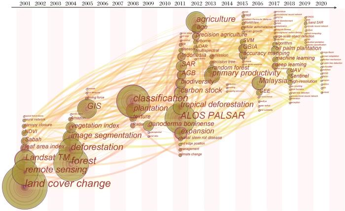
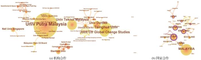
... 基于CiteSpace文献计量学软件[33]可以进行文献的共被引和耦合网络分析、科研合作网络分析以及主题和领域共现网络分析,从而深度挖掘出某研究领域的知识基础、结构框架、研究前沿领域和合作关系,为后续研究提供参考和理论基础. ...
... 本文基于文献共被引分析来深入分析油棕研究被引文献(图中的各个节点)之间的相互关系[33],得到该领域的发展过程和现阶段的研究热点.本文共确定油棕研究8个聚类,分别为逐年油棕种植园制图(annual oil palm plantation map)、土地覆被变化(land cover conversion)、土地覆被分类(land cover classification)、植被指数(vegetation indices)、土地的快速变化(rapid conversion)、油棕茎基腐病(basal stem rot disease)、废弃油棕地(abandoned oil palm land)和驱动因素(driving force). ...
Rapid conversions and avoided deforestation: Examining four decades of industrial plantation expansion in Borneo
1
2016
... 相关研究主要集中在东南亚、非洲和拉丁美洲的赤道附近国家(图1).大部分集中在东南亚地区,占到总量的82.3%,其中马来西亚和印度尼西亚分别占总量的54.6%和21.0%(图2),是油棕研究最为频繁的两个国家.目前,东南亚是全球油棕种植面积最大的地区[34],印度尼西亚和马来西亚更是全球油棕种植面积最大的两个国家,占到全球油棕面积的60%以上,并且在过去几十年一直保持着全球最快的油棕面积扩张速率[2,35]. ...
Estimating aboveground biomass in forest and oil palm plantation in Sabah, Malaysian Borneo using ALOS PALASAR data
4
2011
... 相关研究主要集中在东南亚、非洲和拉丁美洲的赤道附近国家(图1).大部分集中在东南亚地区,占到总量的82.3%,其中马来西亚和印度尼西亚分别占总量的54.6%和21.0%(图2),是油棕研究最为频繁的两个国家.目前,东南亚是全球油棕种植面积最大的地区[34],印度尼西亚和马来西亚更是全球油棕种植面积最大的两个国家,占到全球油棕面积的60%以上,并且在过去几十年一直保持着全球最快的油棕面积扩张速率[2,35]. ...
... 准确估算油棕地上生物量和碳储量,是评估油棕在全球碳循环中作用的基础,对研究全球气候变化具有重要意义[17, 57, 58].虽然MODIS提供GPP产品,但是其对油棕生物量估算的精度欠佳[58].Morel等[35]利用ALOS-PALSAR数据估算马来西亚沙巴州的森林与油棕地上生物量,发现了区分森林和油棕的信号特征,证明该数据集用于监测油棕的潜力,但是SAR数据受环境状况的影响较大.Nunes等[59]开创性地利用激光雷达数据进行碳储量估计,结果显示基于面积的估算方法要优于以树为中心的估算方法,但是准确性仍然较低.多数研究是依据样地数据或者植被指数建立经验回归模型进行估算[35, 60],Foody等[61]尝试利用人工神经网络的方法进行估算,发现NDVI等植被指数与生物量相关性弱且不显著,认为应该充分利用遥感数据的所有波段进行估算.Fan等[62]和Xu等[4]在陆面模式中开发油棕生长模块,模拟油棕生长过程,为未来结合遥感观测数据估算大尺度油棕扩张造成的地上生物量与碳储量变化提供新的研究方法. ...
... [35, 60],Foody等[61]尝试利用人工神经网络的方法进行估算,发现NDVI等植被指数与生物量相关性弱且不显著,认为应该充分利用遥感数据的所有波段进行估算.Fan等[62]和Xu等[4]在陆面模式中开发油棕生长模块,模拟油棕生长过程,为未来结合遥感观测数据估算大尺度油棕扩张造成的地上生物量与碳储量变化提供新的研究方法. ...
... 基于合成孔径雷达(SAR)数据,可以利用油棕种植园规则的种植形态使油棕与其他覆被类型相区别[5, 35, 84, 86, 87].SAR在对地观测上,相较于光学遥感具有明显的优势[39],已经有较多的学者采用了SAR数据,开展基于纹理特征的机器学习等方法的油棕制图研究[5, 39, 42, 84, 87],但是取得的精度并不理想.SAR数据在具有巨大优势的同时也存在着明显的不足,SAR数据波段较少而且影像信噪比低,这就使得SAR数据的油棕制图结果精度不稳定(图7). ...
Oil palm plantation mapping from high-resolution remote sensing images using deep learning
1
2020
... 了解油棕种植园的空间分布情况是油棕研究的基础,开展油棕制图研究的问题主要集中在大尺度制图和利用不同遥感数据与分类方法提高制图精度.现有的油棕制图研究往往追求在较大范围进行(一个国家、州或省等),比如Cheng等[18]、Najib等[1]、Dong等[36]对马来西亚进行了油棕制图研究.所使用的遥感数据以光学遥感数据(Landsat、SPOT(Systeme Probatoire d’Observation de la Terre)、QuickBird、Sentinel-2等)为主,越来越多的学者使用SAR数据(PALSAR、Sentinel-1、Radarsat等)来表现地表纹理特征,但是结果表明使用SAR数据的制图精度并不稳定[7, 18].也有部分学者使用MODIS(Moderate-resolution Imaging Spectroradiometer)数据进行制图,结果较为理想[37].在分类方法上,传统的最大似然分类方法仍然被广泛使用,但是结果精度欠佳[38, 39],基于机器学习的分类方法(RF(Random Forest)、SVM、ANN)越来越受关注,制图精度相较于传统分类方法也有较大提升[6, 40].Cheng等[6]利用MLC、RF和SVM对马来西亚进行油棕制图,结果表明RF(91.07%)和SVM(90.41%)比MLC(89.72%)具有更好的制图精度.油棕制图研究因为主要以识别油棕为主,所以分类系统主要围绕油棕,一般情况下以油棕和其他作为主要类别,但是很多研究都指出低龄油棕难以区分,会影响制图精度[41-43]. ...
Capability of Integrated MODIS imagery and ALOS for oil palm, rubber and forest areas mapping in tropical forest regions
1
2014
... 了解油棕种植园的空间分布情况是油棕研究的基础,开展油棕制图研究的问题主要集中在大尺度制图和利用不同遥感数据与分类方法提高制图精度.现有的油棕制图研究往往追求在较大范围进行(一个国家、州或省等),比如Cheng等[18]、Najib等[1]、Dong等[36]对马来西亚进行了油棕制图研究.所使用的遥感数据以光学遥感数据(Landsat、SPOT(Systeme Probatoire d’Observation de la Terre)、QuickBird、Sentinel-2等)为主,越来越多的学者使用SAR数据(PALSAR、Sentinel-1、Radarsat等)来表现地表纹理特征,但是结果表明使用SAR数据的制图精度并不稳定[7, 18].也有部分学者使用MODIS(Moderate-resolution Imaging Spectroradiometer)数据进行制图,结果较为理想[37].在分类方法上,传统的最大似然分类方法仍然被广泛使用,但是结果精度欠佳[38, 39],基于机器学习的分类方法(RF(Random Forest)、SVM、ANN)越来越受关注,制图精度相较于传统分类方法也有较大提升[6, 40].Cheng等[6]利用MLC、RF和SVM对马来西亚进行油棕制图,结果表明RF(91.07%)和SVM(90.41%)比MLC(89.72%)具有更好的制图精度.油棕制图研究因为主要以识别油棕为主,所以分类系统主要围绕油棕,一般情况下以油棕和其他作为主要类别,但是很多研究都指出低龄油棕难以区分,会影响制图精度[41-43]. ...
Multi-sensor data fusion for modeling african palm in the ecuadorian Amazon
1
2008
... 了解油棕种植园的空间分布情况是油棕研究的基础,开展油棕制图研究的问题主要集中在大尺度制图和利用不同遥感数据与分类方法提高制图精度.现有的油棕制图研究往往追求在较大范围进行(一个国家、州或省等),比如Cheng等[18]、Najib等[1]、Dong等[36]对马来西亚进行了油棕制图研究.所使用的遥感数据以光学遥感数据(Landsat、SPOT(Systeme Probatoire d’Observation de la Terre)、QuickBird、Sentinel-2等)为主,越来越多的学者使用SAR数据(PALSAR、Sentinel-1、Radarsat等)来表现地表纹理特征,但是结果表明使用SAR数据的制图精度并不稳定[7, 18].也有部分学者使用MODIS(Moderate-resolution Imaging Spectroradiometer)数据进行制图,结果较为理想[37].在分类方法上,传统的最大似然分类方法仍然被广泛使用,但是结果精度欠佳[38, 39],基于机器学习的分类方法(RF(Random Forest)、SVM、ANN)越来越受关注,制图精度相较于传统分类方法也有较大提升[6, 40].Cheng等[6]利用MLC、RF和SVM对马来西亚进行油棕制图,结果表明RF(91.07%)和SVM(90.41%)比MLC(89.72%)具有更好的制图精度.油棕制图研究因为主要以识别油棕为主,所以分类系统主要围绕油棕,一般情况下以油棕和其他作为主要类别,但是很多研究都指出低龄油棕难以区分,会影响制图精度[41-43]. ...
Feasibility study of C- and L-band SAR time series data in tracking Indonesian plantation and natural forest cover changes
3
2015
... 了解油棕种植园的空间分布情况是油棕研究的基础,开展油棕制图研究的问题主要集中在大尺度制图和利用不同遥感数据与分类方法提高制图精度.现有的油棕制图研究往往追求在较大范围进行(一个国家、州或省等),比如Cheng等[18]、Najib等[1]、Dong等[36]对马来西亚进行了油棕制图研究.所使用的遥感数据以光学遥感数据(Landsat、SPOT(Systeme Probatoire d’Observation de la Terre)、QuickBird、Sentinel-2等)为主,越来越多的学者使用SAR数据(PALSAR、Sentinel-1、Radarsat等)来表现地表纹理特征,但是结果表明使用SAR数据的制图精度并不稳定[7, 18].也有部分学者使用MODIS(Moderate-resolution Imaging Spectroradiometer)数据进行制图,结果较为理想[37].在分类方法上,传统的最大似然分类方法仍然被广泛使用,但是结果精度欠佳[38, 39],基于机器学习的分类方法(RF(Random Forest)、SVM、ANN)越来越受关注,制图精度相较于传统分类方法也有较大提升[6, 40].Cheng等[6]利用MLC、RF和SVM对马来西亚进行油棕制图,结果表明RF(91.07%)和SVM(90.41%)比MLC(89.72%)具有更好的制图精度.油棕制图研究因为主要以识别油棕为主,所以分类系统主要围绕油棕,一般情况下以油棕和其他作为主要类别,但是很多研究都指出低龄油棕难以区分,会影响制图精度[41-43]. ...
... 基于合成孔径雷达(SAR)数据,可以利用油棕种植园规则的种植形态使油棕与其他覆被类型相区别[5, 35, 84, 86, 87].SAR在对地观测上,相较于光学遥感具有明显的优势[39],已经有较多的学者采用了SAR数据,开展基于纹理特征的机器学习等方法的油棕制图研究[5, 39, 42, 84, 87],但是取得的精度并不理想.SAR数据在具有巨大优势的同时也存在着明显的不足,SAR数据波段较少而且影像信噪比低,这就使得SAR数据的油棕制图结果精度不稳定(图7). ...
... , 39, 42, 84, 87],但是取得的精度并不理想.SAR数据在具有巨大优势的同时也存在着明显的不足,SAR数据波段较少而且影像信噪比低,这就使得SAR数据的油棕制图结果精度不稳定(图7). ...
Mapping the distribution of oil palm using Landsat 8 data by comparing machine learning and non-machine learning algorithms
2
2019
... 了解油棕种植园的空间分布情况是油棕研究的基础,开展油棕制图研究的问题主要集中在大尺度制图和利用不同遥感数据与分类方法提高制图精度.现有的油棕制图研究往往追求在较大范围进行(一个国家、州或省等),比如Cheng等[18]、Najib等[1]、Dong等[36]对马来西亚进行了油棕制图研究.所使用的遥感数据以光学遥感数据(Landsat、SPOT(Systeme Probatoire d’Observation de la Terre)、QuickBird、Sentinel-2等)为主,越来越多的学者使用SAR数据(PALSAR、Sentinel-1、Radarsat等)来表现地表纹理特征,但是结果表明使用SAR数据的制图精度并不稳定[7, 18].也有部分学者使用MODIS(Moderate-resolution Imaging Spectroradiometer)数据进行制图,结果较为理想[37].在分类方法上,传统的最大似然分类方法仍然被广泛使用,但是结果精度欠佳[38, 39],基于机器学习的分类方法(RF(Random Forest)、SVM、ANN)越来越受关注,制图精度相较于传统分类方法也有较大提升[6, 40].Cheng等[6]利用MLC、RF和SVM对马来西亚进行油棕制图,结果表明RF(91.07%)和SVM(90.41%)比MLC(89.72%)具有更好的制图精度.油棕制图研究因为主要以识别油棕为主,所以分类系统主要围绕油棕,一般情况下以油棕和其他作为主要类别,但是很多研究都指出低龄油棕难以区分,会影响制图精度[41-43]. ...
... 在油棕制图研究中,主要采用的分类方法是最大似然分类(MLC)、随机森林(RF)和支持向量机(SVM),而RF与SVM取得的精度更为理想(图8).计算机视觉技术和机器学习技术的蓬勃发展极大地促进了遥感图像识别及信息提取研究[89],并被越来越多地应用于油棕制图研究中[5, 6, 40, 87, 90]. ...
Peat swamp forest conservation withstands pervasive land conversion to oil palm plantation in North Selangor, Malaysia
1
2019
... 了解油棕种植园的空间分布情况是油棕研究的基础,开展油棕制图研究的问题主要集中在大尺度制图和利用不同遥感数据与分类方法提高制图精度.现有的油棕制图研究往往追求在较大范围进行(一个国家、州或省等),比如Cheng等[18]、Najib等[1]、Dong等[36]对马来西亚进行了油棕制图研究.所使用的遥感数据以光学遥感数据(Landsat、SPOT(Systeme Probatoire d’Observation de la Terre)、QuickBird、Sentinel-2等)为主,越来越多的学者使用SAR数据(PALSAR、Sentinel-1、Radarsat等)来表现地表纹理特征,但是结果表明使用SAR数据的制图精度并不稳定[7, 18].也有部分学者使用MODIS(Moderate-resolution Imaging Spectroradiometer)数据进行制图,结果较为理想[37].在分类方法上,传统的最大似然分类方法仍然被广泛使用,但是结果精度欠佳[38, 39],基于机器学习的分类方法(RF(Random Forest)、SVM、ANN)越来越受关注,制图精度相较于传统分类方法也有较大提升[6, 40].Cheng等[6]利用MLC、RF和SVM对马来西亚进行油棕制图,结果表明RF(91.07%)和SVM(90.41%)比MLC(89.72%)具有更好的制图精度.油棕制图研究因为主要以识别油棕为主,所以分类系统主要围绕油棕,一般情况下以油棕和其他作为主要类别,但是很多研究都指出低龄油棕难以区分,会影响制图精度[41-43]. ...
Oil palm (Elaeis guineensis) mapping with details: Smallholder versus Industrial plantations and their extent in Riau, Sumatra
2
2019
... 基于合成孔径雷达(SAR)数据,可以利用油棕种植园规则的种植形态使油棕与其他覆被类型相区别[5, 35, 84, 86, 87].SAR在对地观测上,相较于光学遥感具有明显的优势[39],已经有较多的学者采用了SAR数据,开展基于纹理特征的机器学习等方法的油棕制图研究[5, 39, 42, 84, 87],但是取得的精度并不理想.SAR数据在具有巨大优势的同时也存在着明显的不足,SAR数据波段较少而且影像信噪比低,这就使得SAR数据的油棕制图结果精度不稳定(图7). ...
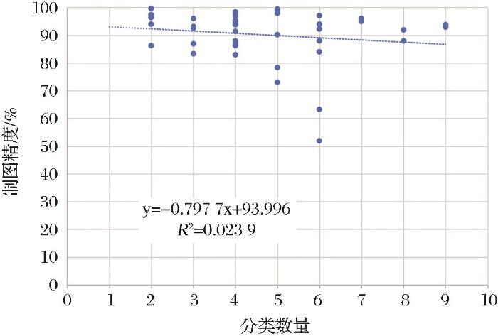
... 一般认为,制图时使用的分类系统越复杂,分类精度将会越低[82].在油棕制图研究中,因为制图对象主要是油棕,所以分类系统较为简单,如仅区分油棕和非油棕.图9显示随着分类系统的类别数量增加,制图精度有着略微下降的趋势.Descals等[42]曾基于Sentinel数据,利用RF分类方法对北苏门答腊的比南加村(village of Binanga)进行油棕制图,结果显示当分类系统类别数量为3时取得的精度(88.6%)要优于类别数量为5时取得的精度(87.2%),这一研究也支持了分类系统类别数量增加会降低制图精度的判断. ...
An optimized object-based analysis for vegetation mapping using integration of QuickBird and Sentinel-1 data
1
2018
... 了解油棕种植园的空间分布情况是油棕研究的基础,开展油棕制图研究的问题主要集中在大尺度制图和利用不同遥感数据与分类方法提高制图精度.现有的油棕制图研究往往追求在较大范围进行(一个国家、州或省等),比如Cheng等[18]、Najib等[1]、Dong等[36]对马来西亚进行了油棕制图研究.所使用的遥感数据以光学遥感数据(Landsat、SPOT(Systeme Probatoire d’Observation de la Terre)、QuickBird、Sentinel-2等)为主,越来越多的学者使用SAR数据(PALSAR、Sentinel-1、Radarsat等)来表现地表纹理特征,但是结果表明使用SAR数据的制图精度并不稳定[7, 18].也有部分学者使用MODIS(Moderate-resolution Imaging Spectroradiometer)数据进行制图,结果较为理想[37].在分类方法上,传统的最大似然分类方法仍然被广泛使用,但是结果精度欠佳[38, 39],基于机器学习的分类方法(RF(Random Forest)、SVM、ANN)越来越受关注,制图精度相较于传统分类方法也有较大提升[6, 40].Cheng等[6]利用MLC、RF和SVM对马来西亚进行油棕制图,结果表明RF(91.07%)和SVM(90.41%)比MLC(89.72%)具有更好的制图精度.油棕制图研究因为主要以识别油棕为主,所以分类系统主要围绕油棕,一般情况下以油棕和其他作为主要类别,但是很多研究都指出低龄油棕难以区分,会影响制图精度[41-43]. ...
Changes in the area cultivated with oil palm in the canton of osa, Puntarenas, 2014-2018 Period
1
2020
... 油棕的变化制图主要是为了研究油棕时空变化特征和驱动因素,监测油棕变化对其他土地覆被类型和生态环境的影响[44, 45],另外对未来油棕变化进行有效预测也十分重要.多个研究指出油棕扩张严重侵占了其他土地覆被类型,尤其是森林、农地、泥炭地等,对生态环境造成严重影响[10, 15, 46].油棕变化制图是在土地利用制图的基础上进行时间维度上的扩展,遥感数据的周期性使得开展逐年油棕变化制图成为可能.De Petris等[15]基于MODIS的增强植被指数(Enhanced Vegetation Index)数据估算了2000至2018年间中加里曼丹(Kalimantan Tengah)的油棕种植园扩张面积,取得了94%的总体精度.基于RS技术只能对过去的油棕变化进行检测,但是基于GIS技术利用时空模拟模型可以模拟未来土地覆被变化,为优化油棕和其他土地覆被类型的空间格局提供参考[47, 48],这为未来油棕研究提供了新思路. ...
Preliminary analysis of the land use dynamic associated with oil palm (Elaeis Guineensis) plantations in Mexico
1
2018
... 油棕的变化制图主要是为了研究油棕时空变化特征和驱动因素,监测油棕变化对其他土地覆被类型和生态环境的影响[44, 45],另外对未来油棕变化进行有效预测也十分重要.多个研究指出油棕扩张严重侵占了其他土地覆被类型,尤其是森林、农地、泥炭地等,对生态环境造成严重影响[10, 15, 46].油棕变化制图是在土地利用制图的基础上进行时间维度上的扩展,遥感数据的周期性使得开展逐年油棕变化制图成为可能.De Petris等[15]基于MODIS的增强植被指数(Enhanced Vegetation Index)数据估算了2000至2018年间中加里曼丹(Kalimantan Tengah)的油棕种植园扩张面积,取得了94%的总体精度.基于RS技术只能对过去的油棕变化进行检测,但是基于GIS技术利用时空模拟模型可以模拟未来土地覆被变化,为优化油棕和其他土地覆被类型的空间格局提供参考[47, 48],这为未来油棕研究提供了新思路. ...
Spatial-temporal evolution and analysis of the driving force of oil palm patterns in Malaysia from 2000 to 2018
1
2020
... 油棕的变化制图主要是为了研究油棕时空变化特征和驱动因素,监测油棕变化对其他土地覆被类型和生态环境的影响[44, 45],另外对未来油棕变化进行有效预测也十分重要.多个研究指出油棕扩张严重侵占了其他土地覆被类型,尤其是森林、农地、泥炭地等,对生态环境造成严重影响[10, 15, 46].油棕变化制图是在土地利用制图的基础上进行时间维度上的扩展,遥感数据的周期性使得开展逐年油棕变化制图成为可能.De Petris等[15]基于MODIS的增强植被指数(Enhanced Vegetation Index)数据估算了2000至2018年间中加里曼丹(Kalimantan Tengah)的油棕种植园扩张面积,取得了94%的总体精度.基于RS技术只能对过去的油棕变化进行检测,但是基于GIS技术利用时空模拟模型可以模拟未来土地覆被变化,为优化油棕和其他土地覆被类型的空间格局提供参考[47, 48],这为未来油棕研究提供了新思路. ...
A GIS-based model to analyze the spatial and temporal development of oil palm land use in Kuala Langat District, Malaysia
1
2015
... 油棕的变化制图主要是为了研究油棕时空变化特征和驱动因素,监测油棕变化对其他土地覆被类型和生态环境的影响[44, 45],另外对未来油棕变化进行有效预测也十分重要.多个研究指出油棕扩张严重侵占了其他土地覆被类型,尤其是森林、农地、泥炭地等,对生态环境造成严重影响[10, 15, 46].油棕变化制图是在土地利用制图的基础上进行时间维度上的扩展,遥感数据的周期性使得开展逐年油棕变化制图成为可能.De Petris等[15]基于MODIS的增强植被指数(Enhanced Vegetation Index)数据估算了2000至2018年间中加里曼丹(Kalimantan Tengah)的油棕种植园扩张面积,取得了94%的总体精度.基于RS技术只能对过去的油棕变化进行检测,但是基于GIS技术利用时空模拟模型可以模拟未来土地覆被变化,为优化油棕和其他土地覆被类型的空间格局提供参考[47, 48],这为未来油棕研究提供了新思路. ...
Multi-Objective-based modeling for land use change analysis in the South West of Selangor, Malaysia
1
2015
... 油棕的变化制图主要是为了研究油棕时空变化特征和驱动因素,监测油棕变化对其他土地覆被类型和生态环境的影响[44, 45],另外对未来油棕变化进行有效预测也十分重要.多个研究指出油棕扩张严重侵占了其他土地覆被类型,尤其是森林、农地、泥炭地等,对生态环境造成严重影响[10, 15, 46].油棕变化制图是在土地利用制图的基础上进行时间维度上的扩展,遥感数据的周期性使得开展逐年油棕变化制图成为可能.De Petris等[15]基于MODIS的增强植被指数(Enhanced Vegetation Index)数据估算了2000至2018年间中加里曼丹(Kalimantan Tengah)的油棕种植园扩张面积,取得了94%的总体精度.基于RS技术只能对过去的油棕变化进行检测,但是基于GIS技术利用时空模拟模型可以模拟未来土地覆被变化,为优化油棕和其他土地覆被类型的空间格局提供参考[47, 48],这为未来油棕研究提供了新思路. ...
Single-tree detection in high-resolution remote-sensing images based on a cascade neural network
1
2018
... 油棕树计数是对油棕种植园进行产量估算、种植园管理和空间布局规划的基础.因为其对遥感数据空间分辨率的高要求,未来无人机遥感数据将是油棕树计数的主要数据源.传统的油棕树计数会消耗大量的时间和人力,遥感提供了油棕树计数的新思路.基于遥感图像,通过图像处理和机器学习技术可以准确估算图像范围内的油棕树数量.与油棕制图不同,计数对遥感图像的空间分辨率要求较高.在现有研究中,多采用QuickBird、WorldView等达到米级或者亚米级空间分辨率的遥感数据[3, 49-51];越来越多的研究使用无人机遥感图像,因为无人机遥感图像不仅具有更高空间分辨率,而且数据的获取更具便捷性、实时性 [24, 52].从检测方法上看,多采用机器学习的方法,卷积神经网络(Convolutional Neural Network,CNN)使用最多,其次为支持向量机(SVM)和面向对象的图像分析(OBIA),都取得了比较理想的精度,但是存在区域上的差异.Zheng等[25]提出了一种新的跨区域油棕树检测方法(Multi-level Attention Domain Adaptation Network,MADAN),统计精度要优于现有的域适应方法,但是不能保证在更复杂、更大范围仍然适用. ...
Deep learning based oil palm tree detection and counting for high-resolution remote sensing images
0
2017
A simple method for detection and counting of oil palm trees using high-resolution multispectral satellite imagery
1
2016
... 油棕树计数是对油棕种植园进行产量估算、种植园管理和空间布局规划的基础.因为其对遥感数据空间分辨率的高要求,未来无人机遥感数据将是油棕树计数的主要数据源.传统的油棕树计数会消耗大量的时间和人力,遥感提供了油棕树计数的新思路.基于遥感图像,通过图像处理和机器学习技术可以准确估算图像范围内的油棕树数量.与油棕制图不同,计数对遥感图像的空间分辨率要求较高.在现有研究中,多采用QuickBird、WorldView等达到米级或者亚米级空间分辨率的遥感数据[3, 49-51];越来越多的研究使用无人机遥感图像,因为无人机遥感图像不仅具有更高空间分辨率,而且数据的获取更具便捷性、实时性 [24, 52].从检测方法上看,多采用机器学习的方法,卷积神经网络(Convolutional Neural Network,CNN)使用最多,其次为支持向量机(SVM)和面向对象的图像分析(OBIA),都取得了比较理想的精度,但是存在区域上的差异.Zheng等[25]提出了一种新的跨区域油棕树检测方法(Multi-level Attention Domain Adaptation Network,MADAN),统计精度要优于现有的域适应方法,但是不能保证在更复杂、更大范围仍然适用. ...
Unmanned Aerial Vehicle (UAV) derived structure-from-motion photogrammetry point clouds for oil palm (Elaeis Guineensis) canopy segmentation and height estimation
1
2019
... 油棕树计数是对油棕种植园进行产量估算、种植园管理和空间布局规划的基础.因为其对遥感数据空间分辨率的高要求,未来无人机遥感数据将是油棕树计数的主要数据源.传统的油棕树计数会消耗大量的时间和人力,遥感提供了油棕树计数的新思路.基于遥感图像,通过图像处理和机器学习技术可以准确估算图像范围内的油棕树数量.与油棕制图不同,计数对遥感图像的空间分辨率要求较高.在现有研究中,多采用QuickBird、WorldView等达到米级或者亚米级空间分辨率的遥感数据[3, 49-51];越来越多的研究使用无人机遥感图像,因为无人机遥感图像不仅具有更高空间分辨率,而且数据的获取更具便捷性、实时性 [24, 52].从检测方法上看,多采用机器学习的方法,卷积神经网络(Convolutional Neural Network,CNN)使用最多,其次为支持向量机(SVM)和面向对象的图像分析(OBIA),都取得了比较理想的精度,但是存在区域上的差异.Zheng等[25]提出了一种新的跨区域油棕树检测方法(Multi-level Attention Domain Adaptation Network,MADAN),统计精度要优于现有的域适应方法,但是不能保证在更复杂、更大范围仍然适用. ...
Textural measures for estimating oil palm age
2
2019
... 油棕树龄是预测产量的一个重要指标[19, 53].树龄估算中使用SAR数据要优于光学遥感数据.与油棕树计数不同的是,树龄估算不需要精确到每一棵树,因为在油棕种植时,往往是大块区域种植,而相同树龄的油棕往往具有相似的结构纹理和光谱特征.在油棕树龄估算研究中,光学遥感数据(WorldView、Landsat等)和SAR数据(PALSAR等)均有使用,使用SAR数据通常可以取得更好的精度.多数研究是基于纹理信息来识别油棕的不同生长阶段[53-55],部分研究利用光学波段比值或者油棕生物物理参数(叶面积、冠层覆盖率、茎高等)与油棕树龄进行拟合,挑选相关性强的指标估算油棕树龄[19, 56].Avtar等[54]利用多频率、多极化SAR数据监测马来西亚沙捞越(Sarawak)的油棕生长阶段,结果发现具有HV极化的PALSAR数据对油棕树龄的敏感性最高. ...
... [53-55],部分研究利用光学波段比值或者油棕生物物理参数(叶面积、冠层覆盖率、茎高等)与油棕树龄进行拟合,挑选相关性强的指标估算油棕树龄[19, 56].Avtar等[54]利用多频率、多极化SAR数据监测马来西亚沙捞越(Sarawak)的油棕生长阶段,结果发现具有HV极化的PALSAR数据对油棕树龄的敏感性最高. ...
Efficiency of multi-frequency, multi-polarized SAR data to monitor growth stages of oil palm plants in Sarawak, Malaysia
1
2013
... 油棕树龄是预测产量的一个重要指标[19, 53].树龄估算中使用SAR数据要优于光学遥感数据.与油棕树计数不同的是,树龄估算不需要精确到每一棵树,因为在油棕种植时,往往是大块区域种植,而相同树龄的油棕往往具有相似的结构纹理和光谱特征.在油棕树龄估算研究中,光学遥感数据(WorldView、Landsat等)和SAR数据(PALSAR等)均有使用,使用SAR数据通常可以取得更好的精度.多数研究是基于纹理信息来识别油棕的不同生长阶段[53-55],部分研究利用光学波段比值或者油棕生物物理参数(叶面积、冠层覆盖率、茎高等)与油棕树龄进行拟合,挑选相关性强的指标估算油棕树龄[19, 56].Avtar等[54]利用多频率、多极化SAR数据监测马来西亚沙捞越(Sarawak)的油棕生长阶段,结果发现具有HV极化的PALSAR数据对油棕树龄的敏感性最高. ...
Use of UK-DMC 2 and ALOS PALSAR for studying the age of oil palm trees in Southern Peninsular Malaysia
1
2013
... 油棕树龄是预测产量的一个重要指标[19, 53].树龄估算中使用SAR数据要优于光学遥感数据.与油棕树计数不同的是,树龄估算不需要精确到每一棵树,因为在油棕种植时,往往是大块区域种植,而相同树龄的油棕往往具有相似的结构纹理和光谱特征.在油棕树龄估算研究中,光学遥感数据(WorldView、Landsat等)和SAR数据(PALSAR等)均有使用,使用SAR数据通常可以取得更好的精度.多数研究是基于纹理信息来识别油棕的不同生长阶段[53-55],部分研究利用光学波段比值或者油棕生物物理参数(叶面积、冠层覆盖率、茎高等)与油棕树龄进行拟合,挑选相关性强的指标估算油棕树龄[19, 56].Avtar等[54]利用多频率、多极化SAR数据监测马来西亚沙捞越(Sarawak)的油棕生长阶段,结果发现具有HV极化的PALSAR数据对油棕树龄的敏感性最高. ...
Linear regression modelling for the estimation of oil palm age from Landsat TM
1
2001
... 油棕树龄是预测产量的一个重要指标[19, 53].树龄估算中使用SAR数据要优于光学遥感数据.与油棕树计数不同的是,树龄估算不需要精确到每一棵树,因为在油棕种植时,往往是大块区域种植,而相同树龄的油棕往往具有相似的结构纹理和光谱特征.在油棕树龄估算研究中,光学遥感数据(WorldView、Landsat等)和SAR数据(PALSAR等)均有使用,使用SAR数据通常可以取得更好的精度.多数研究是基于纹理信息来识别油棕的不同生长阶段[53-55],部分研究利用光学波段比值或者油棕生物物理参数(叶面积、冠层覆盖率、茎高等)与油棕树龄进行拟合,挑选相关性强的指标估算油棕树龄[19, 56].Avtar等[54]利用多频率、多极化SAR数据监测马来西亚沙捞越(Sarawak)的油棕生长阶段,结果发现具有HV极化的PALSAR数据对油棕树龄的敏感性最高. ...
Primary forest cover loss in Indonesia over 2000-2012
1
2014
... 准确估算油棕地上生物量和碳储量,是评估油棕在全球碳循环中作用的基础,对研究全球气候变化具有重要意义[17, 57, 58].虽然MODIS提供GPP产品,但是其对油棕生物量估算的精度欠佳[58].Morel等[35]利用ALOS-PALSAR数据估算马来西亚沙巴州的森林与油棕地上生物量,发现了区分森林和油棕的信号特征,证明该数据集用于监测油棕的潜力,但是SAR数据受环境状况的影响较大.Nunes等[59]开创性地利用激光雷达数据进行碳储量估计,结果显示基于面积的估算方法要优于以树为中心的估算方法,但是准确性仍然较低.多数研究是依据样地数据或者植被指数建立经验回归模型进行估算[35, 60],Foody等[61]尝试利用人工神经网络的方法进行估算,发现NDVI等植被指数与生物量相关性弱且不显著,认为应该充分利用遥感数据的所有波段进行估算.Fan等[62]和Xu等[4]在陆面模式中开发油棕生长模块,模拟油棕生长过程,为未来结合遥感观测数据估算大尺度油棕扩张造成的地上生物量与碳储量变化提供新的研究方法. ...
Evaluation of MODIS gross primary productivity and land cover products for the humid tropics using oil palm trees in Peninsular Malaysia and Google Earth Imagery
2
2013
... 准确估算油棕地上生物量和碳储量,是评估油棕在全球碳循环中作用的基础,对研究全球气候变化具有重要意义[17, 57, 58].虽然MODIS提供GPP产品,但是其对油棕生物量估算的精度欠佳[58].Morel等[35]利用ALOS-PALSAR数据估算马来西亚沙巴州的森林与油棕地上生物量,发现了区分森林和油棕的信号特征,证明该数据集用于监测油棕的潜力,但是SAR数据受环境状况的影响较大.Nunes等[59]开创性地利用激光雷达数据进行碳储量估计,结果显示基于面积的估算方法要优于以树为中心的估算方法,但是准确性仍然较低.多数研究是依据样地数据或者植被指数建立经验回归模型进行估算[35, 60],Foody等[61]尝试利用人工神经网络的方法进行估算,发现NDVI等植被指数与生物量相关性弱且不显著,认为应该充分利用遥感数据的所有波段进行估算.Fan等[62]和Xu等[4]在陆面模式中开发油棕生长模块,模拟油棕生长过程,为未来结合遥感观测数据估算大尺度油棕扩张造成的地上生物量与碳储量变化提供新的研究方法. ...
... [58].Morel等[35]利用ALOS-PALSAR数据估算马来西亚沙巴州的森林与油棕地上生物量,发现了区分森林和油棕的信号特征,证明该数据集用于监测油棕的潜力,但是SAR数据受环境状况的影响较大.Nunes等[59]开创性地利用激光雷达数据进行碳储量估计,结果显示基于面积的估算方法要优于以树为中心的估算方法,但是准确性仍然较低.多数研究是依据样地数据或者植被指数建立经验回归模型进行估算[35, 60],Foody等[61]尝试利用人工神经网络的方法进行估算,发现NDVI等植被指数与生物量相关性弱且不显著,认为应该充分利用遥感数据的所有波段进行估算.Fan等[62]和Xu等[4]在陆面模式中开发油棕生长模块,模拟油棕生长过程,为未来结合遥感观测数据估算大尺度油棕扩张造成的地上生物量与碳储量变化提供新的研究方法. ...
Mapping aboveground carbon in oil palm plantations using LiDAR: A comparison of tree-centric versus area-based approaches
1
2017
... 准确估算油棕地上生物量和碳储量,是评估油棕在全球碳循环中作用的基础,对研究全球气候变化具有重要意义[17, 57, 58].虽然MODIS提供GPP产品,但是其对油棕生物量估算的精度欠佳[58].Morel等[35]利用ALOS-PALSAR数据估算马来西亚沙巴州的森林与油棕地上生物量,发现了区分森林和油棕的信号特征,证明该数据集用于监测油棕的潜力,但是SAR数据受环境状况的影响较大.Nunes等[59]开创性地利用激光雷达数据进行碳储量估计,结果显示基于面积的估算方法要优于以树为中心的估算方法,但是准确性仍然较低.多数研究是依据样地数据或者植被指数建立经验回归模型进行估算[35, 60],Foody等[61]尝试利用人工神经网络的方法进行估算,发现NDVI等植被指数与生物量相关性弱且不显著,认为应该充分利用遥感数据的所有波段进行估算.Fan等[62]和Xu等[4]在陆面模式中开发油棕生长模块,模拟油棕生长过程,为未来结合遥感观测数据估算大尺度油棕扩张造成的地上生物量与碳储量变化提供新的研究方法. ...
Biomass estimations and carbon stock calculations in the oil palm plantations of African derived Savannas using IKONOS data
2
2004
... 准确估算油棕地上生物量和碳储量,是评估油棕在全球碳循环中作用的基础,对研究全球气候变化具有重要意义[17, 57, 58].虽然MODIS提供GPP产品,但是其对油棕生物量估算的精度欠佳[58].Morel等[35]利用ALOS-PALSAR数据估算马来西亚沙巴州的森林与油棕地上生物量,发现了区分森林和油棕的信号特征,证明该数据集用于监测油棕的潜力,但是SAR数据受环境状况的影响较大.Nunes等[59]开创性地利用激光雷达数据进行碳储量估计,结果显示基于面积的估算方法要优于以树为中心的估算方法,但是准确性仍然较低.多数研究是依据样地数据或者植被指数建立经验回归模型进行估算[35, 60],Foody等[61]尝试利用人工神经网络的方法进行估算,发现NDVI等植被指数与生物量相关性弱且不显著,认为应该充分利用遥感数据的所有波段进行估算.Fan等[62]和Xu等[4]在陆面模式中开发油棕生长模块,模拟油棕生长过程,为未来结合遥感观测数据估算大尺度油棕扩张造成的地上生物量与碳储量变化提供新的研究方法. ...
... 目前,多源遥感数据的联合是油棕制图的重要方向,尤其是结合光学遥感数据和SAR数据进行油棕制图[1, 7, 18].结合遥感图像的光谱特征和纹理信息可以更容易地将油棕与周围地物区分开来,从而提高油棕制图的精度[60, 88]. ...
Mapping the biomass of bornean tropical rain forest from remotely sensed data
1
2001
... 准确估算油棕地上生物量和碳储量,是评估油棕在全球碳循环中作用的基础,对研究全球气候变化具有重要意义[17, 57, 58].虽然MODIS提供GPP产品,但是其对油棕生物量估算的精度欠佳[58].Morel等[35]利用ALOS-PALSAR数据估算马来西亚沙巴州的森林与油棕地上生物量,发现了区分森林和油棕的信号特征,证明该数据集用于监测油棕的潜力,但是SAR数据受环境状况的影响较大.Nunes等[59]开创性地利用激光雷达数据进行碳储量估计,结果显示基于面积的估算方法要优于以树为中心的估算方法,但是准确性仍然较低.多数研究是依据样地数据或者植被指数建立经验回归模型进行估算[35, 60],Foody等[61]尝试利用人工神经网络的方法进行估算,发现NDVI等植被指数与生物量相关性弱且不显著,认为应该充分利用遥感数据的所有波段进行估算.Fan等[62]和Xu等[4]在陆面模式中开发油棕生长模块,模拟油棕生长过程,为未来结合遥感观测数据估算大尺度油棕扩张造成的地上生物量与碳储量变化提供新的研究方法. ...
A sub-canopy structure for simulating oil palm in the community land model (Clm-Palm): Phenology, allocation and yield
1
2015
... 准确估算油棕地上生物量和碳储量,是评估油棕在全球碳循环中作用的基础,对研究全球气候变化具有重要意义[17, 57, 58].虽然MODIS提供GPP产品,但是其对油棕生物量估算的精度欠佳[58].Morel等[35]利用ALOS-PALSAR数据估算马来西亚沙巴州的森林与油棕地上生物量,发现了区分森林和油棕的信号特征,证明该数据集用于监测油棕的潜力,但是SAR数据受环境状况的影响较大.Nunes等[59]开创性地利用激光雷达数据进行碳储量估计,结果显示基于面积的估算方法要优于以树为中心的估算方法,但是准确性仍然较低.多数研究是依据样地数据或者植被指数建立经验回归模型进行估算[35, 60],Foody等[61]尝试利用人工神经网络的方法进行估算,发现NDVI等植被指数与生物量相关性弱且不显著,认为应该充分利用遥感数据的所有波段进行估算.Fan等[62]和Xu等[4]在陆面模式中开发油棕生长模块,模拟油棕生长过程,为未来结合遥感观测数据估算大尺度油棕扩张造成的地上生物量与碳储量变化提供新的研究方法. ...
Nonlinear growth models for modeling oil palm yield growth
1
2005
... 棕榈油作为一个重要的全球性商品,准确估算油棕产量对制定适当的经营策略具有重要意义[16].目前估算油棕产量的研究工作较少,因为油棕鲜果穗隐藏在树冠之下,遥感无法直接地准确检测,利用植被指数进行间接估算成为主要的手段.有研究指出油棕产量与树龄和某些植被指数之间具有显著的相关性[63, 64],这说明利用光学遥感数据(Landsat、QuickBird)进行产量间接估算是可行的. Balasundram等[64]对植被指数和产量数据进行回归建模与模型验证,最终发现比值植被指数(Ratio Vegetation Index, RVI)和绿波段归一化差值植被指数(Green Normalized Vegetation Index, GNDVI)在产量估算中具有可靠的准确性. ...
Estimating oil palm yields using vegetation indices derived from QuickBird
2
2013
... 棕榈油作为一个重要的全球性商品,准确估算油棕产量对制定适当的经营策略具有重要意义[16].目前估算油棕产量的研究工作较少,因为油棕鲜果穗隐藏在树冠之下,遥感无法直接地准确检测,利用植被指数进行间接估算成为主要的手段.有研究指出油棕产量与树龄和某些植被指数之间具有显著的相关性[63, 64],这说明利用光学遥感数据(Landsat、QuickBird)进行产量间接估算是可行的. Balasundram等[64]对植被指数和产量数据进行回归建模与模型验证,最终发现比值植被指数(Ratio Vegetation Index, RVI)和绿波段归一化差值植被指数(Green Normalized Vegetation Index, GNDVI)在产量估算中具有可靠的准确性. ...
... [64]对植被指数和产量数据进行回归建模与模型验证,最终发现比值植被指数(Ratio Vegetation Index, RVI)和绿波段归一化差值植被指数(Green Normalized Vegetation Index, GNDVI)在产量估算中具有可靠的准确性. ...
Analysis of changes in oil palm canopy architecture from basal stem rot using terrestrial laser scanner
2
2019
... 疾病和虫害会导致油棕大幅度减产,并且降低油棕经济寿命,造成严重的经济损失[65].在油棕病虫害监测中,高光谱和高空间分辨率遥感数据(QuickBird、WorldView、航空和地面平台、便携式设备等)使用较多,利用环境要素进行病虫害监测也是一种重要的方法,但是目前对疾病早期的检测仍是难点.常见的油棕病虫害包括茎基腐病(basal stem rot)、结草虫(bagworm)等.基于高光谱分辨率遥感数据研究中,通常是利用光谱反射率或者光谱反射率导数曲线特征检测茎基腐病的感染程度,而利用光谱反射率导数的方法具有更高的精度[66-68];基于高空间分辨率遥感数据的研究则是利用光谱波段比(如植被指数)进行检测,结果精度差异较大,对于轻度染病油棕的检测仍然存在缺陷[69-72].越来越多学者尝试利用地面或者航空遥感方式来检测油棕染病情况,如地面激光扫描、手持式平台、直升机平台、无人机等,这些方式能够便捷、实时地获取数据[65, 67, 68, 73, 74].油棕茎基腐病目前没有有效的防治措施,只能延长寿命,而病虫害通常会突然爆发,利用遥感手段监测存在难度.油棕病害的发生往往与地面因素相关,因此Rakib等[75]基于GIS技术分析泥炭人工林中铜、锌与茎基腐病发生的空间相关性,结果表明铜、锌含量低或许是茎基腐病发生的原因.对于虫害的监测需要更为实时的数据,所以多采用低空遥感数据,而且因为害虫对周围环境更为敏感,所以研究中会考虑加入环境参数,如相对湿度、地表温度、降雨等,而这些数据往往需要匹配GNSS技术提供的高精度位置信息[29]. ...
... [65, 67, 68, 73, 74].油棕茎基腐病目前没有有效的防治措施,只能延长寿命,而病虫害通常会突然爆发,利用遥感手段监测存在难度.油棕病害的发生往往与地面因素相关,因此Rakib等[75]基于GIS技术分析泥炭人工林中铜、锌与茎基腐病发生的空间相关性,结果表明铜、锌含量低或许是茎基腐病发生的原因.对于虫害的监测需要更为实时的数据,所以多采用低空遥感数据,而且因为害虫对周围环境更为敏感,所以研究中会考虑加入环境参数,如相对湿度、地表温度、降雨等,而这些数据往往需要匹配GNSS技术提供的高精度位置信息[29]. ...
Spectral discrimination of healthy and ganoderma-infected oil palms from hyperspectral data
1
2011
... 疾病和虫害会导致油棕大幅度减产,并且降低油棕经济寿命,造成严重的经济损失[65].在油棕病虫害监测中,高光谱和高空间分辨率遥感数据(QuickBird、WorldView、航空和地面平台、便携式设备等)使用较多,利用环境要素进行病虫害监测也是一种重要的方法,但是目前对疾病早期的检测仍是难点.常见的油棕病虫害包括茎基腐病(basal stem rot)、结草虫(bagworm)等.基于高光谱分辨率遥感数据研究中,通常是利用光谱反射率或者光谱反射率导数曲线特征检测茎基腐病的感染程度,而利用光谱反射率导数的方法具有更高的精度[66-68];基于高空间分辨率遥感数据的研究则是利用光谱波段比(如植被指数)进行检测,结果精度差异较大,对于轻度染病油棕的检测仍然存在缺陷[69-72].越来越多学者尝试利用地面或者航空遥感方式来检测油棕染病情况,如地面激光扫描、手持式平台、直升机平台、无人机等,这些方式能够便捷、实时地获取数据[65, 67, 68, 73, 74].油棕茎基腐病目前没有有效的防治措施,只能延长寿命,而病虫害通常会突然爆发,利用遥感手段监测存在难度.油棕病害的发生往往与地面因素相关,因此Rakib等[75]基于GIS技术分析泥炭人工林中铜、锌与茎基腐病发生的空间相关性,结果表明铜、锌含量低或许是茎基腐病发生的原因.对于虫害的监测需要更为实时的数据,所以多采用低空遥感数据,而且因为害虫对周围环境更为敏感,所以研究中会考虑加入环境参数,如相对湿度、地表温度、降雨等,而这些数据往往需要匹配GNSS技术提供的高精度位置信息[29]. ...
Early detection of basal stem rot disease (Ganoderma) in oil palms based on hyperspectral reflectance data using pattern recognition algorithms
1
2014
... 疾病和虫害会导致油棕大幅度减产,并且降低油棕经济寿命,造成严重的经济损失[65].在油棕病虫害监测中,高光谱和高空间分辨率遥感数据(QuickBird、WorldView、航空和地面平台、便携式设备等)使用较多,利用环境要素进行病虫害监测也是一种重要的方法,但是目前对疾病早期的检测仍是难点.常见的油棕病虫害包括茎基腐病(basal stem rot)、结草虫(bagworm)等.基于高光谱分辨率遥感数据研究中,通常是利用光谱反射率或者光谱反射率导数曲线特征检测茎基腐病的感染程度,而利用光谱反射率导数的方法具有更高的精度[66-68];基于高空间分辨率遥感数据的研究则是利用光谱波段比(如植被指数)进行检测,结果精度差异较大,对于轻度染病油棕的检测仍然存在缺陷[69-72].越来越多学者尝试利用地面或者航空遥感方式来检测油棕染病情况,如地面激光扫描、手持式平台、直升机平台、无人机等,这些方式能够便捷、实时地获取数据[65, 67, 68, 73, 74].油棕茎基腐病目前没有有效的防治措施,只能延长寿命,而病虫害通常会突然爆发,利用遥感手段监测存在难度.油棕病害的发生往往与地面因素相关,因此Rakib等[75]基于GIS技术分析泥炭人工林中铜、锌与茎基腐病发生的空间相关性,结果表明铜、锌含量低或许是茎基腐病发生的原因.对于虫害的监测需要更为实时的数据,所以多采用低空遥感数据,而且因为害虫对周围环境更为敏感,所以研究中会考虑加入环境参数,如相对湿度、地表温度、降雨等,而这些数据往往需要匹配GNSS技术提供的高精度位置信息[29]. ...
Mid-infrared spectroscopy for early detection of basal stem rot disease in oil palm
2
2014
... 疾病和虫害会导致油棕大幅度减产,并且降低油棕经济寿命,造成严重的经济损失[65].在油棕病虫害监测中,高光谱和高空间分辨率遥感数据(QuickBird、WorldView、航空和地面平台、便携式设备等)使用较多,利用环境要素进行病虫害监测也是一种重要的方法,但是目前对疾病早期的检测仍是难点.常见的油棕病虫害包括茎基腐病(basal stem rot)、结草虫(bagworm)等.基于高光谱分辨率遥感数据研究中,通常是利用光谱反射率或者光谱反射率导数曲线特征检测茎基腐病的感染程度,而利用光谱反射率导数的方法具有更高的精度[66-68];基于高空间分辨率遥感数据的研究则是利用光谱波段比(如植被指数)进行检测,结果精度差异较大,对于轻度染病油棕的检测仍然存在缺陷[69-72].越来越多学者尝试利用地面或者航空遥感方式来检测油棕染病情况,如地面激光扫描、手持式平台、直升机平台、无人机等,这些方式能够便捷、实时地获取数据[65, 67, 68, 73, 74].油棕茎基腐病目前没有有效的防治措施,只能延长寿命,而病虫害通常会突然爆发,利用遥感手段监测存在难度.油棕病害的发生往往与地面因素相关,因此Rakib等[75]基于GIS技术分析泥炭人工林中铜、锌与茎基腐病发生的空间相关性,结果表明铜、锌含量低或许是茎基腐病发生的原因.对于虫害的监测需要更为实时的数据,所以多采用低空遥感数据,而且因为害虫对周围环境更为敏感,所以研究中会考虑加入环境参数,如相对湿度、地表温度、降雨等,而这些数据往往需要匹配GNSS技术提供的高精度位置信息[29]. ...
... , 68, 73, 74].油棕茎基腐病目前没有有效的防治措施,只能延长寿命,而病虫害通常会突然爆发,利用遥感手段监测存在难度.油棕病害的发生往往与地面因素相关,因此Rakib等[75]基于GIS技术分析泥炭人工林中铜、锌与茎基腐病发生的空间相关性,结果表明铜、锌含量低或许是茎基腐病发生的原因.对于虫害的监测需要更为实时的数据,所以多采用低空遥感数据,而且因为害虫对周围环境更为敏感,所以研究中会考虑加入环境参数,如相对湿度、地表温度、降雨等,而这些数据往往需要匹配GNSS技术提供的高精度位置信息[29]. ...
Random forest classification model of basal stem rot disease caused by Ganoderma boninense in oil palm plantations
1
2017
... 疾病和虫害会导致油棕大幅度减产,并且降低油棕经济寿命,造成严重的经济损失[65].在油棕病虫害监测中,高光谱和高空间分辨率遥感数据(QuickBird、WorldView、航空和地面平台、便携式设备等)使用较多,利用环境要素进行病虫害监测也是一种重要的方法,但是目前对疾病早期的检测仍是难点.常见的油棕病虫害包括茎基腐病(basal stem rot)、结草虫(bagworm)等.基于高光谱分辨率遥感数据研究中,通常是利用光谱反射率或者光谱反射率导数曲线特征检测茎基腐病的感染程度,而利用光谱反射率导数的方法具有更高的精度[66-68];基于高空间分辨率遥感数据的研究则是利用光谱波段比(如植被指数)进行检测,结果精度差异较大,对于轻度染病油棕的检测仍然存在缺陷[69-72].越来越多学者尝试利用地面或者航空遥感方式来检测油棕染病情况,如地面激光扫描、手持式平台、直升机平台、无人机等,这些方式能够便捷、实时地获取数据[65, 67, 68, 73, 74].油棕茎基腐病目前没有有效的防治措施,只能延长寿命,而病虫害通常会突然爆发,利用遥感手段监测存在难度.油棕病害的发生往往与地面因素相关,因此Rakib等[75]基于GIS技术分析泥炭人工林中铜、锌与茎基腐病发生的空间相关性,结果表明铜、锌含量低或许是茎基腐病发生的原因.对于虫害的监测需要更为实时的数据,所以多采用低空遥感数据,而且因为害虫对周围环境更为敏感,所以研究中会考虑加入环境参数,如相对湿度、地表温度、降雨等,而这些数据往往需要匹配GNSS技术提供的高精度位置信息[29]. ...
Classifying the severity of basal stem rot disease in oil palm plantations using Worldview-3 imagery and machine learning algorithms
0
2019
Analysis of multispectral imagery from Unmanned Aerial Vehicle (UAV) using object-based image analysis for detection of ganoderma disease in oil palm
0
2020
Mapping and identifying basal stem rot disease in oil palms in North Sumatra with QuickBird imagery
1
2010
... 疾病和虫害会导致油棕大幅度减产,并且降低油棕经济寿命,造成严重的经济损失[65].在油棕病虫害监测中,高光谱和高空间分辨率遥感数据(QuickBird、WorldView、航空和地面平台、便携式设备等)使用较多,利用环境要素进行病虫害监测也是一种重要的方法,但是目前对疾病早期的检测仍是难点.常见的油棕病虫害包括茎基腐病(basal stem rot)、结草虫(bagworm)等.基于高光谱分辨率遥感数据研究中,通常是利用光谱反射率或者光谱反射率导数曲线特征检测茎基腐病的感染程度,而利用光谱反射率导数的方法具有更高的精度[66-68];基于高空间分辨率遥感数据的研究则是利用光谱波段比(如植被指数)进行检测,结果精度差异较大,对于轻度染病油棕的检测仍然存在缺陷[69-72].越来越多学者尝试利用地面或者航空遥感方式来检测油棕染病情况,如地面激光扫描、手持式平台、直升机平台、无人机等,这些方式能够便捷、实时地获取数据[65, 67, 68, 73, 74].油棕茎基腐病目前没有有效的防治措施,只能延长寿命,而病虫害通常会突然爆发,利用遥感手段监测存在难度.油棕病害的发生往往与地面因素相关,因此Rakib等[75]基于GIS技术分析泥炭人工林中铜、锌与茎基腐病发生的空间相关性,结果表明铜、锌含量低或许是茎基腐病发生的原因.对于虫害的监测需要更为实时的数据,所以多采用低空遥感数据,而且因为害虫对周围环境更为敏感,所以研究中会考虑加入环境参数,如相对湿度、地表温度、降雨等,而这些数据往往需要匹配GNSS技术提供的高精度位置信息[29]. ...
Oil palm pest infestation monitoring and evaluation by helicopter-moun-ted, low altitude remote sensing platform
1
2011
... 疾病和虫害会导致油棕大幅度减产,并且降低油棕经济寿命,造成严重的经济损失[65].在油棕病虫害监测中,高光谱和高空间分辨率遥感数据(QuickBird、WorldView、航空和地面平台、便携式设备等)使用较多,利用环境要素进行病虫害监测也是一种重要的方法,但是目前对疾病早期的检测仍是难点.常见的油棕病虫害包括茎基腐病(basal stem rot)、结草虫(bagworm)等.基于高光谱分辨率遥感数据研究中,通常是利用光谱反射率或者光谱反射率导数曲线特征检测茎基腐病的感染程度,而利用光谱反射率导数的方法具有更高的精度[66-68];基于高空间分辨率遥感数据的研究则是利用光谱波段比(如植被指数)进行检测,结果精度差异较大,对于轻度染病油棕的检测仍然存在缺陷[69-72].越来越多学者尝试利用地面或者航空遥感方式来检测油棕染病情况,如地面激光扫描、手持式平台、直升机平台、无人机等,这些方式能够便捷、实时地获取数据[65, 67, 68, 73, 74].油棕茎基腐病目前没有有效的防治措施,只能延长寿命,而病虫害通常会突然爆发,利用遥感手段监测存在难度.油棕病害的发生往往与地面因素相关,因此Rakib等[75]基于GIS技术分析泥炭人工林中铜、锌与茎基腐病发生的空间相关性,结果表明铜、锌含量低或许是茎基腐病发生的原因.对于虫害的监测需要更为实时的数据,所以多采用低空遥感数据,而且因为害虫对周围环境更为敏感,所以研究中会考虑加入环境参数,如相对湿度、地表温度、降雨等,而这些数据往往需要匹配GNSS技术提供的高精度位置信息[29]. ...
Application of ground-based LiDAR for analysing oil palm canopy properties on the occurrence of Basal Stem Rot (BSR) Disease
1
2020
... 疾病和虫害会导致油棕大幅度减产,并且降低油棕经济寿命,造成严重的经济损失[65].在油棕病虫害监测中,高光谱和高空间分辨率遥感数据(QuickBird、WorldView、航空和地面平台、便携式设备等)使用较多,利用环境要素进行病虫害监测也是一种重要的方法,但是目前对疾病早期的检测仍是难点.常见的油棕病虫害包括茎基腐病(basal stem rot)、结草虫(bagworm)等.基于高光谱分辨率遥感数据研究中,通常是利用光谱反射率或者光谱反射率导数曲线特征检测茎基腐病的感染程度,而利用光谱反射率导数的方法具有更高的精度[66-68];基于高空间分辨率遥感数据的研究则是利用光谱波段比(如植被指数)进行检测,结果精度差异较大,对于轻度染病油棕的检测仍然存在缺陷[69-72].越来越多学者尝试利用地面或者航空遥感方式来检测油棕染病情况,如地面激光扫描、手持式平台、直升机平台、无人机等,这些方式能够便捷、实时地获取数据[65, 67, 68, 73, 74].油棕茎基腐病目前没有有效的防治措施,只能延长寿命,而病虫害通常会突然爆发,利用遥感手段监测存在难度.油棕病害的发生往往与地面因素相关,因此Rakib等[75]基于GIS技术分析泥炭人工林中铜、锌与茎基腐病发生的空间相关性,结果表明铜、锌含量低或许是茎基腐病发生的原因.对于虫害的监测需要更为实时的数据,所以多采用低空遥感数据,而且因为害虫对周围环境更为敏感,所以研究中会考虑加入环境参数,如相对湿度、地表温度、降雨等,而这些数据往往需要匹配GNSS技术提供的高精度位置信息[29]. ...
Association of copper and zinc levels in oil palm (Elaeis Guineensis) to the spatial distribution of ganoderma species in the plantations on peat
1
2017
... 疾病和虫害会导致油棕大幅度减产,并且降低油棕经济寿命,造成严重的经济损失[65].在油棕病虫害监测中,高光谱和高空间分辨率遥感数据(QuickBird、WorldView、航空和地面平台、便携式设备等)使用较多,利用环境要素进行病虫害监测也是一种重要的方法,但是目前对疾病早期的检测仍是难点.常见的油棕病虫害包括茎基腐病(basal stem rot)、结草虫(bagworm)等.基于高光谱分辨率遥感数据研究中,通常是利用光谱反射率或者光谱反射率导数曲线特征检测茎基腐病的感染程度,而利用光谱反射率导数的方法具有更高的精度[66-68];基于高空间分辨率遥感数据的研究则是利用光谱波段比(如植被指数)进行检测,结果精度差异较大,对于轻度染病油棕的检测仍然存在缺陷[69-72].越来越多学者尝试利用地面或者航空遥感方式来检测油棕染病情况,如地面激光扫描、手持式平台、直升机平台、无人机等,这些方式能够便捷、实时地获取数据[65, 67, 68, 73, 74].油棕茎基腐病目前没有有效的防治措施,只能延长寿命,而病虫害通常会突然爆发,利用遥感手段监测存在难度.油棕病害的发生往往与地面因素相关,因此Rakib等[75]基于GIS技术分析泥炭人工林中铜、锌与茎基腐病发生的空间相关性,结果表明铜、锌含量低或许是茎基腐病发生的原因.对于虫害的监测需要更为实时的数据,所以多采用低空遥感数据,而且因为害虫对周围环境更为敏感,所以研究中会考虑加入环境参数,如相对湿度、地表温度、降雨等,而这些数据往往需要匹配GNSS技术提供的高精度位置信息[29]. ...
What are the limits to oil palm expansion?
2
2016
... 探索油棕种植适宜性并且评估可种植区域是油棕产业可持续发展的重要环节.当前研究表明,气候条件是限制油棕生长的主要因素,地形、土壤和社会经济等条件均会起到限制作用,而GIS技术是进行适宜性评估的主要手段.马来西亚和印度尼西亚的油棕面积即将超过或者已经超过其维持可持续发展的油棕种植面积[76],探索其他地区可种植油棕的土地迫在眉睫.Pirker等[76]评估了全球的油棕可种植区,发现气候条件是主要限制性因素,并且可种植区与高碳储量森林和保护区高度重合,这导致剩余可种植油棕的土地极少.土壤是一切植物生长的基础,Ogunkunle等[77]评估了尼日利亚的4个土壤系列的油棕可种植性,发现土壤肥力和颗粒大小是主要限制条件.社会经济条件在土地适宜性评估中同样重要,结合社会经济条件有助于改善对未来可扩张地区的预测[78].Olaniyi等[79]在考虑社会经济条件的情况下评估了马来西亚的农业用地适宜性,结果发现油棕最适宜种植区在雪莪兰州的沙白安南区(Sabak Bernam district)和瓜拉冷岳(Kuala Langat)县. ...
... [76]评估了全球的油棕可种植区,发现气候条件是主要限制性因素,并且可种植区与高碳储量森林和保护区高度重合,这导致剩余可种植油棕的土地极少.土壤是一切植物生长的基础,Ogunkunle等[77]评估了尼日利亚的4个土壤系列的油棕可种植性,发现土壤肥力和颗粒大小是主要限制条件.社会经济条件在土地适宜性评估中同样重要,结合社会经济条件有助于改善对未来可扩张地区的预测[78].Olaniyi等[79]在考虑社会经济条件的情况下评估了马来西亚的农业用地适宜性,结果发现油棕最适宜种植区在雪莪兰州的沙白安南区(Sabak Bernam district)和瓜拉冷岳(Kuala Langat)县. ...
Soil in land suitability evaluation-An exa-mple with oil palm in Nigeria
1
1993
... 探索油棕种植适宜性并且评估可种植区域是油棕产业可持续发展的重要环节.当前研究表明,气候条件是限制油棕生长的主要因素,地形、土壤和社会经济等条件均会起到限制作用,而GIS技术是进行适宜性评估的主要手段.马来西亚和印度尼西亚的油棕面积即将超过或者已经超过其维持可持续发展的油棕种植面积[76],探索其他地区可种植油棕的土地迫在眉睫.Pirker等[76]评估了全球的油棕可种植区,发现气候条件是主要限制性因素,并且可种植区与高碳储量森林和保护区高度重合,这导致剩余可种植油棕的土地极少.土壤是一切植物生长的基础,Ogunkunle等[77]评估了尼日利亚的4个土壤系列的油棕可种植性,发现土壤肥力和颗粒大小是主要限制条件.社会经济条件在土地适宜性评估中同样重要,结合社会经济条件有助于改善对未来可扩张地区的预测[78].Olaniyi等[79]在考虑社会经济条件的情况下评估了马来西亚的农业用地适宜性,结果发现油棕最适宜种植区在雪莪兰州的沙白安南区(Sabak Bernam district)和瓜拉冷岳(Kuala Langat)县. ...
Biophysical and socioeconomic drivers of oil palm expansion in Indonesia
1
2020
... 探索油棕种植适宜性并且评估可种植区域是油棕产业可持续发展的重要环节.当前研究表明,气候条件是限制油棕生长的主要因素,地形、土壤和社会经济等条件均会起到限制作用,而GIS技术是进行适宜性评估的主要手段.马来西亚和印度尼西亚的油棕面积即将超过或者已经超过其维持可持续发展的油棕种植面积[76],探索其他地区可种植油棕的土地迫在眉睫.Pirker等[76]评估了全球的油棕可种植区,发现气候条件是主要限制性因素,并且可种植区与高碳储量森林和保护区高度重合,这导致剩余可种植油棕的土地极少.土壤是一切植物生长的基础,Ogunkunle等[77]评估了尼日利亚的4个土壤系列的油棕可种植性,发现土壤肥力和颗粒大小是主要限制条件.社会经济条件在土地适宜性评估中同样重要,结合社会经济条件有助于改善对未来可扩张地区的预测[78].Olaniyi等[79]在考虑社会经济条件的情况下评估了马来西亚的农业用地适宜性,结果发现油棕最适宜种植区在雪莪兰州的沙白安南区(Sabak Bernam district)和瓜拉冷岳(Kuala Langat)县. ...
Agricultural land use suitability assessment in Malaysia
1
2015
... 探索油棕种植适宜性并且评估可种植区域是油棕产业可持续发展的重要环节.当前研究表明,气候条件是限制油棕生长的主要因素,地形、土壤和社会经济等条件均会起到限制作用,而GIS技术是进行适宜性评估的主要手段.马来西亚和印度尼西亚的油棕面积即将超过或者已经超过其维持可持续发展的油棕种植面积[76],探索其他地区可种植油棕的土地迫在眉睫.Pirker等[76]评估了全球的油棕可种植区,发现气候条件是主要限制性因素,并且可种植区与高碳储量森林和保护区高度重合,这导致剩余可种植油棕的土地极少.土壤是一切植物生长的基础,Ogunkunle等[77]评估了尼日利亚的4个土壤系列的油棕可种植性,发现土壤肥力和颗粒大小是主要限制条件.社会经济条件在土地适宜性评估中同样重要,结合社会经济条件有助于改善对未来可扩张地区的预测[78].Olaniyi等[79]在考虑社会经济条件的情况下评估了马来西亚的农业用地适宜性,结果发现油棕最适宜种植区在雪莪兰州的沙白安南区(Sabak Bernam district)和瓜拉冷岳(Kuala Langat)县. ...
Monitoring oil palm plantations in Malaysia
1
2016
... 对油棕种植园合理的管理不仅可以减少对环境的污染,而且可以提高种植园的经济效益.种植园管理包括种植道路规划、地形规划、油棕种植、水肥管理、病虫害监测等,传统管理方法费时费力,经济效益低,3S技术为其提供了新思路.3S技术是实现精准农业的核心技术,利用雷达遥感数据获取无云图像,光学遥感数据获取种植园的重要物理参数,可以获得种植园的整体状况[80];GNSS可以提供精确位置信息,辅助信息采集和空间配准;配合GIS整合各种环境数据,可以实现对种植园的信息监控和智慧管理.Shafri等[81]利用LiDAR和光学遥感数据为油棕种植园进行种植道路和地形规划,极大地提升了种植园管理的准确度和效率,为种植园带来更大的利润,但是目前仍没有在更大规模油棕种植园的实践. ...
Application of LiDAR and optical data for oil palm plantation management in Malaysia
1
2012
... 对油棕种植园合理的管理不仅可以减少对环境的污染,而且可以提高种植园的经济效益.种植园管理包括种植道路规划、地形规划、油棕种植、水肥管理、病虫害监测等,传统管理方法费时费力,经济效益低,3S技术为其提供了新思路.3S技术是实现精准农业的核心技术,利用雷达遥感数据获取无云图像,光学遥感数据获取种植园的重要物理参数,可以获得种植园的整体状况[80];GNSS可以提供精确位置信息,辅助信息采集和空间配准;配合GIS整合各种环境数据,可以实现对种植园的信息监控和智慧管理.Shafri等[81]利用LiDAR和光学遥感数据为油棕种植园进行种植道路和地形规划,极大地提升了种植园管理的准确度和效率,为种植园带来更大的利润,但是目前仍没有在更大规模油棕种植园的实践. ...
Meta-discoveries from a synthesis of satellite-based land-cover mapping research
2
2014
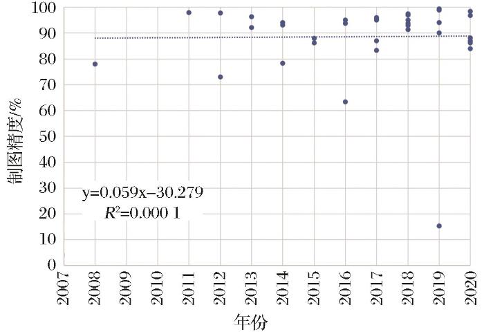
... 在油棕制图研究中,制图精度与论文出版时间并无显著关系(图5),可能的原因是随着制图技术的发展,研究区域和使用的遥感数据量越来越大,制图目标也越来越复杂[82]. ...
... 一般认为,制图时使用的分类系统越复杂,分类精度将会越低[82].在油棕制图研究中,因为制图对象主要是油棕,所以分类系统较为简单,如仅区分油棕和非油棕.图9显示随着分类系统的类别数量增加,制图精度有着略微下降的趋势.Descals等[42]曾基于Sentinel数据,利用RF分类方法对北苏门答腊的比南加村(village of Binanga)进行油棕制图,结果显示当分类系统类别数量为3时取得的精度(88.6%)要优于类别数量为5时取得的精度(87.2%),这一研究也支持了分类系统类别数量增加会降低制图精度的判断. ...
遥感影像空间尺度特性与最佳空间分辨率选择
2
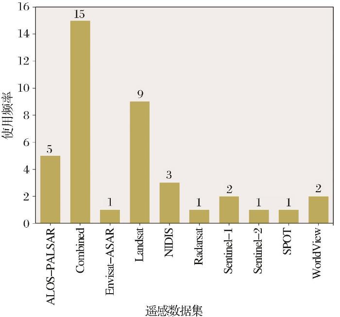
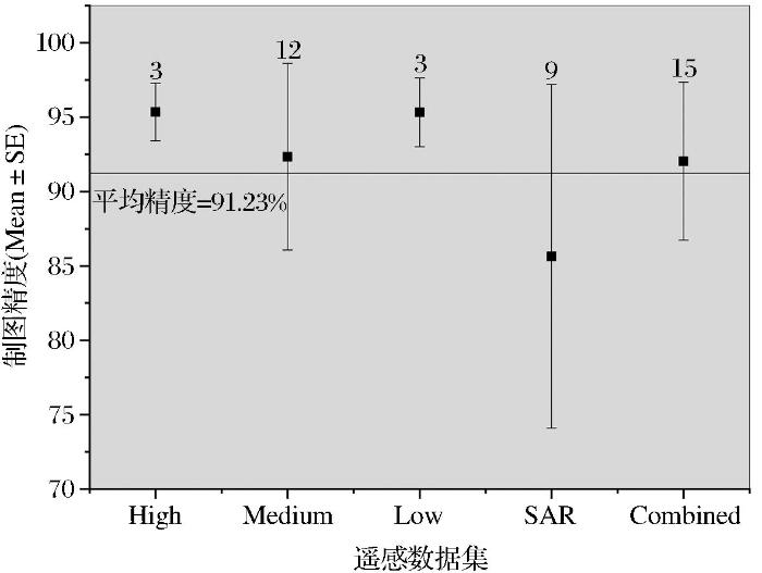
2008
... 遥感图像的空间分辨率大小对分类精度有重要影响,因此最佳空间分辨率的选择被认为是对地观测的主要挑战之一[83].因此,依据遥感卫星数据类型(光学:高(High)、中(Medium)、低(Low)空间分辨率,SAR,多源遥感数据结合(Combined)),分析不同遥感数据集的分类精度差异(图7).但是如图7所示,不同分辨率遥感数据在油棕制图精度方差棒重叠,因此,分辨率对制图精度的影响差异并不明显.相较于高分辨率数据,低空间分辨率遥感数据能够更好地表现出油棕的大尺度空间现象,且更少受图像噪声的影响[84].高空间分辨率遥感数据可以减少混合像元数量,在一定程度上提高油棕制图分类精度[83],如Yusoff等[85]就曾采用相同的分类方法和分类系统,分别基于SPOT-6与Landsat OLI(Operational Land Imager)遥感数据在马来西亚霹雳州的瓜拉江沙区(Kuala Kangsar district)进行油棕制图研究,结果分别取得了96%和87%的分类精度. ...
... [83],如Yusoff等[85]就曾采用相同的分类方法和分类系统,分别基于SPOT-6与Landsat OLI(Operational Land Imager)遥感数据在马来西亚霹雳州的瓜拉江沙区(Kuala Kangsar district)进行油棕制图研究,结果分别取得了96%和87%的分类精度. ...
遥感影像空间尺度特性与最佳空间分辨率选择
2
2008
... 遥感图像的空间分辨率大小对分类精度有重要影响,因此最佳空间分辨率的选择被认为是对地观测的主要挑战之一[83].因此,依据遥感卫星数据类型(光学:高(High)、中(Medium)、低(Low)空间分辨率,SAR,多源遥感数据结合(Combined)),分析不同遥感数据集的分类精度差异(图7).但是如图7所示,不同分辨率遥感数据在油棕制图精度方差棒重叠,因此,分辨率对制图精度的影响差异并不明显.相较于高分辨率数据,低空间分辨率遥感数据能够更好地表现出油棕的大尺度空间现象,且更少受图像噪声的影响[84].高空间分辨率遥感数据可以减少混合像元数量,在一定程度上提高油棕制图分类精度[83],如Yusoff等[85]就曾采用相同的分类方法和分类系统,分别基于SPOT-6与Landsat OLI(Operational Land Imager)遥感数据在马来西亚霹雳州的瓜拉江沙区(Kuala Kangsar district)进行油棕制图研究,结果分别取得了96%和87%的分类精度. ...
... [83],如Yusoff等[85]就曾采用相同的分类方法和分类系统,分别基于SPOT-6与Landsat OLI(Operational Land Imager)遥感数据在马来西亚霹雳州的瓜拉江沙区(Kuala Kangsar district)进行油棕制图研究,结果分别取得了96%和87%的分类精度. ...
Using multiscale texture information from ALOS PALSAR to map tropical forest
3
2012
... 遥感图像的空间分辨率大小对分类精度有重要影响,因此最佳空间分辨率的选择被认为是对地观测的主要挑战之一[83].因此,依据遥感卫星数据类型(光学:高(High)、中(Medium)、低(Low)空间分辨率,SAR,多源遥感数据结合(Combined)),分析不同遥感数据集的分类精度差异(图7).但是如图7所示,不同分辨率遥感数据在油棕制图精度方差棒重叠,因此,分辨率对制图精度的影响差异并不明显.相较于高分辨率数据,低空间分辨率遥感数据能够更好地表现出油棕的大尺度空间现象,且更少受图像噪声的影响[84].高空间分辨率遥感数据可以减少混合像元数量,在一定程度上提高油棕制图分类精度[83],如Yusoff等[85]就曾采用相同的分类方法和分类系统,分别基于SPOT-6与Landsat OLI(Operational Land Imager)遥感数据在马来西亚霹雳州的瓜拉江沙区(Kuala Kangsar district)进行油棕制图研究,结果分别取得了96%和87%的分类精度. ...
... 基于合成孔径雷达(SAR)数据,可以利用油棕种植园规则的种植形态使油棕与其他覆被类型相区别[5, 35, 84, 86, 87].SAR在对地观测上,相较于光学遥感具有明显的优势[39],已经有较多的学者采用了SAR数据,开展基于纹理特征的机器学习等方法的油棕制图研究[5, 39, 42, 84, 87],但是取得的精度并不理想.SAR数据在具有巨大优势的同时也存在着明显的不足,SAR数据波段较少而且影像信噪比低,这就使得SAR数据的油棕制图结果精度不稳定(图7). ...
... , 84, 87],但是取得的精度并不理想.SAR数据在具有巨大优势的同时也存在着明显的不足,SAR数据波段较少而且影像信噪比低,这就使得SAR数据的油棕制图结果精度不稳定(图7). ...
Towards the use of remote-sensing data for monitoring of abandoned oil palm lands in Malaysia: A semi-automatic approach
1
2017
... 遥感图像的空间分辨率大小对分类精度有重要影响,因此最佳空间分辨率的选择被认为是对地观测的主要挑战之一[83].因此,依据遥感卫星数据类型(光学:高(High)、中(Medium)、低(Low)空间分辨率,SAR,多源遥感数据结合(Combined)),分析不同遥感数据集的分类精度差异(图7).但是如图7所示,不同分辨率遥感数据在油棕制图精度方差棒重叠,因此,分辨率对制图精度的影响差异并不明显.相较于高分辨率数据,低空间分辨率遥感数据能够更好地表现出油棕的大尺度空间现象,且更少受图像噪声的影响[84].高空间分辨率遥感数据可以减少混合像元数量,在一定程度上提高油棕制图分类精度[83],如Yusoff等[85]就曾采用相同的分类方法和分类系统,分别基于SPOT-6与Landsat OLI(Operational Land Imager)遥感数据在马来西亚霹雳州的瓜拉江沙区(Kuala Kangsar district)进行油棕制图研究,结果分别取得了96%和87%的分类精度. ...
Remotely sensed evidence of tropical peatland conversion to oil palm
1
2011
... 基于合成孔径雷达(SAR)数据,可以利用油棕种植园规则的种植形态使油棕与其他覆被类型相区别[5, 35, 84, 86, 87].SAR在对地观测上,相较于光学遥感具有明显的优势[39],已经有较多的学者采用了SAR数据,开展基于纹理特征的机器学习等方法的油棕制图研究[5, 39, 42, 84, 87],但是取得的精度并不理想.SAR数据在具有巨大优势的同时也存在着明显的不足,SAR数据波段较少而且影像信噪比低,这就使得SAR数据的油棕制图结果精度不稳定(图7). ...
Mapping oil palm plantations in cameroon using PALSAR 50 m orthorectified mosaic images
3
2015
... 基于合成孔径雷达(SAR)数据,可以利用油棕种植园规则的种植形态使油棕与其他覆被类型相区别[5, 35, 84, 86, 87].SAR在对地观测上,相较于光学遥感具有明显的优势[39],已经有较多的学者采用了SAR数据,开展基于纹理特征的机器学习等方法的油棕制图研究[5, 39, 42, 84, 87],但是取得的精度并不理想.SAR数据在具有巨大优势的同时也存在着明显的不足,SAR数据波段较少而且影像信噪比低,这就使得SAR数据的油棕制图结果精度不稳定(图7). ...
... , 87],但是取得的精度并不理想.SAR数据在具有巨大优势的同时也存在着明显的不足,SAR数据波段较少而且影像信噪比低,这就使得SAR数据的油棕制图结果精度不稳定(图7). ...
... 在油棕制图研究中,主要采用的分类方法是最大似然分类(MLC)、随机森林(RF)和支持向量机(SVM),而RF与SVM取得的精度更为理想(图8).计算机视觉技术和机器学习技术的蓬勃发展极大地促进了遥感图像识别及信息提取研究[89],并被越来越多地应用于油棕制图研究中[5, 6, 40, 87, 90]. ...
Carbon emissions from forest conversion by Kalimantan oil palm plantations
1
2012
... 目前,多源遥感数据的联合是油棕制图的重要方向,尤其是结合光学遥感数据和SAR数据进行油棕制图[1, 7, 18].结合遥感图像的光谱特征和纹理信息可以更容易地将油棕与周围地物区分开来,从而提高油棕制图的精度[60, 88]. ...
基于FPGA的遥感目标检测加速器的研究与实现
1
2020
... 在油棕制图研究中,主要采用的分类方法是最大似然分类(MLC)、随机森林(RF)和支持向量机(SVM),而RF与SVM取得的精度更为理想(图8).计算机视觉技术和机器学习技术的蓬勃发展极大地促进了遥感图像识别及信息提取研究[89],并被越来越多地应用于油棕制图研究中[5, 6, 40, 87, 90]. ...
基于FPGA的遥感目标检测加速器的研究与实现
1
2020
... 在油棕制图研究中,主要采用的分类方法是最大似然分类(MLC)、随机森林(RF)和支持向量机(SVM),而RF与SVM取得的精度更为理想(图8).计算机视觉技术和机器学习技术的蓬勃发展极大地促进了遥感图像识别及信息提取研究[89],并被越来越多地应用于油棕制图研究中[5, 6, 40, 87, 90]. ...
Support vector machine to map oil palm in a heterogeneous environment
1
2014
... 在油棕制图研究中,主要采用的分类方法是最大似然分类(MLC)、随机森林(RF)和支持向量机(SVM),而RF与SVM取得的精度更为理想(图8).计算机视觉技术和机器学习技术的蓬勃发展极大地促进了遥感图像识别及信息提取研究[89],并被越来越多地应用于油棕制图研究中[5, 6, 40, 87, 90]. ...


