1 引 言
在青藏高原众多的环境要素中,土壤水分值得关注。一方面,它是地气水分交互作用的“调节器”,影响着降水、入渗、径流、蒸散发的量化分配[21-23];另一方面,它是刻画地气纵向空间的“驱动器”,影响着地表覆被、土壤性状、生态资源等环境条件的存续状况[24-27]。在第二次青藏高原综合科学考察研究、中科院战略性先导科技专项、中德“泛第三极环境变化与丝绸之路建设专项”等研究计划的支持下[28-29],针对土壤水分、降水、温度等多种要素,以玛曲、那曲等多个代表性的地面监测站网已在青藏高原地区布设完成并实现数据积累[30-32],为气候模拟、灾害分析、模型与算法验证等多样化的研究与应用提供了关键支撑[33-34]。
针对青藏高原土壤水分,卓嘎利用多源融合数据分析了不同深度下土壤水分分布特征(2009—2010年),发现其呈现浅层和深层低湿、中间层高湿的特点,且具有显著的季节变化特征[35]。Bai等[36]利用GLDAS-Noah(Global Land Data Assimilation System-Noah)数据分析了青藏高原土壤水分的时空分布特征(1950—2010年),并探讨了温度和降水对其变化的相对贡献,研究发现土壤水分在空间上呈现南高北低、在时间上呈现波动变化的趋势,降水对土壤水分的影响较大,而温度对二者关系有一定的调节作用。Cheng等[37]利用实测数据评估了ESA CCI(European Space Agency Climate Change Initiative)和ERA5(ECMWF Reanalysis V5)土壤水分数据产品在青藏高原的可靠性,并进一步利用ERA5数据分析了土壤水分的时空分布和年际变化规律(1979—2018年),研究发现土壤水分自东南向西北逐渐下降,但全域呈总体增长态势,与降水增加、蒸散发下降的背景特征相符。Shi等[38]利用ESA CCI数据和MODIS LAI(Moderate Resolution Ima-ging Spectroradiometer Leaf Area Index)数据研究了青藏高原土壤水分和植被的时空变化趋势(2000—2019年),并基于实测插值网格数据及ERA5数据对驱动因子(降水、气温)进行了分析,结果表明青藏高原呈现变湿和变绿趋势,降水和温度分别为土壤水分及植被变化的主要驱动因素。
在被动微波观测模式下,SMOS和SMAP都采用了低频率的L波段,尽管在硬件和探测机理上各具特色,但反演目标和数据体系的设置多有相似之处,因此常被互作比较[43-48]。截止目前,它们的数据池已分别累积到近13 a和近7 a,初步具备了支持长时序分析的能力,在此基础上,完全依托星载微波遥感数据而不借助于模拟或同化手段、以土壤水分为研究主体而非过程变量,开展其长消时空特征研究值得一试。研究选定青藏高原为典型区,原因在于其地理位置特殊、环境特征显著,不仅是当前地球系统科学研究的热门地区,同时也是SMOS、SMAP等多源土壤水分数据进行验证、对比的热点地区;拟开展青藏高原土壤水分长消特征研究,并初步探讨地表类型约束下的土壤水分与降水和蒸散发的耦合关系;研究旨在明确近期青藏高原土壤水分的总体分布状况,为地区和全球气候及灾害的预测预报研究提供科学依据。
2 数 据
为开展青藏高原土壤水分的长消特征研究,将使用三大类共计6种数据,分别是:①星载微波土壤水分数据,主要为SMOS和SMAP Level 2(L2)数据,原因在于它们是基于观测亮温的直接反演结果,反映了从观测、模拟到反演计算的整个算法背景,未经单日、全球合成或同化处理;②地面实测数据,主要来自于国际土壤水分网ISMN(International Soil Moisture Network),选用其中的5 cm土壤温度数据,用于判定与季风和植被生长季相符合的研究时段;③其他辅助数据,包括GPCP(Global Precipitation Climatology Project)降水数据、MODIS蒸散发数据、C3S(Copernicus Climate Change Service) Global LC(Global Land Cover)地表覆被数据,这些数据被用于进行对土壤水分变化的耦合分析,选用的原因在于满足免费、全球性、时间和空间尺度精细、具有通用性等普适条件。以下将逐一简述各项数据的具体情况。
2.1 星载微波土壤水分数据
(1)SMOS L2 土壤水分数据:SMOS是由欧洲航天局ESA(European Space Agency)于2009年发射的土壤水分(和海洋盐度)专题卫星(微波,被动),针对土壤水分设置了L2、L3、L4三级数据,其中L2数据是以观测亮温(L1)为输入的直接反演输出,同时又被作为输入来合成L3单日全球数据,是SMOS具有代表性的数据产品。研究采用的是2011—2020年的SMOS L2土壤水分数据(SM_REPR_MIR_SMUDP2_*,V650,https:∥smos-diss.eo.esa.int/),它采用ISEA 4h9(Icosahedral Snyder Equal Area)格网体系进行空间组织,格点尺度约为15 km;土壤水分按照体积含水量的方式进行量化(m3/m3),精度设置为0.04 m3/m3[49-50]。
(2)SMAP L2 土壤水分数据:SMAP是由美国航空航天局NASA(National Aeronautics and Space Administration)于2015年发射的土壤水分专题卫星(微波、主被动),其对土壤水分数据的设置也分为L2、L3、L4 3个级别。本文选用L2被动数据,原因同样在于它是直接反演输出,体现了观测、模拟和反演计算背景,且未经过合成或同化处理,同SMOS L2数据具有对照性。研究使用2016—2020年的SMAP L2土壤水分数据(SMAP_L2_SM_P_*,V7,
表1 SMOS和SMAP土壤水分数据质量控制条件
Table 1
| 数据 | 控制条件 | 控制量 |
|---|---|---|
SMOS (MIR_SMUDP2) | DQX(the Data Quality Index) | >0 |
| Science_Flags | (Bit 1)==0 | |
SMAP (L2_SM_P) | static water fraction | <5% |
| urban area | <25% | |
| precipitation/snow/permanent ice/frozen ground fraction | <5% | |
| slope standard deviation | <3% |
2.2 地面实测数据
选用ISMN土壤温度(Soil Temperature)实测数据,用于确定与季风和植被生长季相符的研究时段。ISMN的建设目的是实现以土壤水分为主的全球地面实测数据的共享,截止目前已有30个国家和地区的73个观测网络、共计2 882个观测站点加盟,这些地面实测数据已经成为国际公认的支持土壤水分研究不可或缺的数据基础[53-55]。在青藏高原地区当前有3个实测站网加入ISMN,分别为MAQU(东部)、NAQU(中部)和NGARI(西部)。除了(多层)土壤水分外,土壤温度和降水也被作为同步观测要素。根据3个站网的共同时间范围,本文使用2011—2019年的5 cm土壤温度数据(https:∥www.geo.tuwien.ac.at/insitu/data_viewer/),时间分辨率为1 h,单位为℃。
2.3 其他辅助数据
(3)C3S Global地表覆被数据:地表覆被类型是与土壤水分存续状况密切相关的环境条件,也是影响降水落地分配、蒸散发作用强度的主要因素。本文选用欧洲中尺度天气预报中心ECMWF(European Centre for Medium-Range Weather Forecasts)的C3S地表覆被数据Global LC(C3S-LC-L4-LCCS-Map-300m-*,
由于辅助数据主要为多源、多尺度的合成型数据,时间单元也不一致;根据其各自的提供时间和与SMOS、SMAP数据的对照情况,研究将选用辅助数据的时段统一为2016—2020年。
3 方 法
3.1 确定研究时段
表2 3站网5 cm土壤温度分布状况
Table 2
| 土壤温度 | 站网 | 5月 | 6月 | 7月 | 8月 | 9月 | 10月 |
|---|---|---|---|---|---|---|---|
| MAQU | √ | √ | |||||
| NAQU | √ | √ | |||||
| NGARI | √ | √ | |||||
| MAQU | √ | √ | √ | √ | |||
| NAQU | √ | √ | √ | ||||
| NGARI | √ | √ | √ | ||||
| MAQU | √ | √ | √ | √ | |||
| NAQU | √ | √ | √ | ||||
| NGARI | √ | √ | √ |
3.2 统一时空尺度
研究采用的星载微波土壤水分数据(SMOS L2、SMAP L2)和辅助数据(GPCP降水、MOD16A2蒸散发、C3S Global LC地类)的空间尺度和时间单元不同,需要进行统一,具体方法如下。在空间上,各种数据的组织方式不同,但对格点中心位置处(土壤水分数据)或边界位置处(辅助数据)的经纬度都进行了标记,因此,采用“中心—中心最邻近(球面距离)”的方式进行多源数据的空间匹配。在时间上采用年份匹配的方法。SMOS和SMAP数据根据观测时间被赋以UTC(Universal Time Coordinated)标准时间戳、精确到秒,辅助数据则采用8天、月份、年份等时间单位,因此,对照7—9月这一研究时段,将多源数据分别求取此时段内的平均值并按年份标记,从而实现在时间上的统一。
3.3 量化分析指标
从土壤水分自身的增减变化和其与环境条件的耦合机制两个方面进行量化分析。以SMOS和SMAP的各个格点为计算单元,利用土壤水分与时间之间的相关系数
利用偏相关系数
4 结果与讨论
4.1 土壤水分时空长消特征
(1)时序趋势
图1
图1
青藏高原土壤水分变化趋势
Fig.1
Variation trend of soil moisture in Qinghai-Tibet Plateau
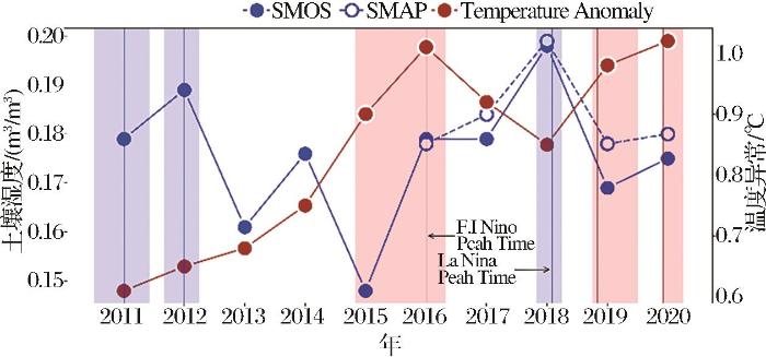
2011—2020年土壤水分的波动大致可以分为3个阶段。第一阶段为2011—2015年,在此期间仅有SMOS数据,土壤水分呈现波动式下降趋势;第二阶段为2015—2018年,此时开始有SMAP数据,且与SMOS共同捕捉到了土壤水分连续升高的态势;第三阶段为2018—2020年,土壤水分快速下降并随后小幅升高。
SMOS和SMAP反映出青藏高原的土壤水分在时序上表现出显著波动、整体上升的趋势;在2016—2020的数据共同时段内,SMOS和SMAP对土壤水分的反映具有良好的一致性;同时,土壤水分的变化与全球温度和大型气候事件背景在时间序列上有一定的同步性;且在土壤水分变化的3个阶段内,全球温度异常与土壤水分的变化在时间上具有较强的耦合关系,而在趋势上呈相反态势。同时,将土壤水分的高低变化和极值转折与厄尔尼诺和拉尼娜事件的持续时间进行比照后也发现一定的关联性。这或在某种程度上体现出青藏高原对全球地气系统作用的敏感性,以及土壤水分作为关键环境变量的指示性。
(2)空间分布
图2
图2
青藏高原地区7—9月SMOS、SMAP多年平均土壤水分空间分布 审图号:2019(1819)
Fig.2
Spatial distribution of SMOS and SMAP multi-year average soil moisture in the Qinghai-Tibet Plateau from July to September
(3)长消特征
图3
图3
青藏高原7-9月SMOS、SMAP年平均土壤水分时空变化特征 审图号:2019(1819)
Fig.3
Spatial and temporal variation characteristics of year average soil moisture in SMOS and SMAP in the Qinghai-Tibet Plateau from July to September
在青海及藏东南等地势较低、河流汇集、土壤水分值较高的区域,
综上所述,在季风及植被生长季内青藏高原土壤水分的长消变化呈现出东部上升、西部及西北部下降的整体特征。SMOS和SMAP在各自观测时段内所捕获的土壤水分长消趋势在空间上具有较好的一致性。
4.2 与关键要素的耦合特征
(1)降水和蒸散发的空间分布特征
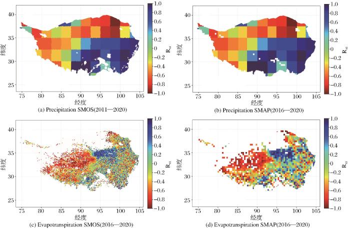
降水与蒸散发作为土壤水分的主要输入、输出量,它们的空间分布与变化深刻影响土壤水分的长消趋势。研究利用GPCP降水数据和MOD16A2蒸散发数据讨论了青藏高原地区的降水和蒸散发的增减变化,结果如图4所示。受冰雪覆盖影响,蒸散发数据在西北部存在缺失,因此对蒸散发的分析仅包含具有数据记录的区域。
图4
图4
青藏高原地区基于SMOS、SMAP格网的降水与蒸散发时空变化特征 审图号:2019(1819)
Fig.4
Temporal and spatial variation characteristics of precipitation and evapotranspiration based on SMOS and SMAP grid in Qinghai Tibet Plateau
青藏高原的降水变化与季风行进方向一致,随着印度季风和东南亚季风的推进,降水呈现自东南向西北方向
(2)地类空间分布特征
表3 青藏高原地区各地类在所属大类中的占比
Table 3
| 类别 | SMOS/% | SMAP/% | |
|---|---|---|---|
| 低矮植被 | 农田 | 7.80 | 9.45 |
| 草地 | 92.20 | 90.55 | |
| 林地 | 森林 | 87.14 | 89.17 |
| 灌木 | 1.37 | 1.27 | |
| 稀疏植被 | 11.49 | 9.55 | |
| 裸地 | 裸地 | 100.00 | 100.00 |
图5
图5
青藏高原地区基于SMOS、SMAP格网的主要地表类型分布 审图号:2019(1819)
Fig.5
Distribution of main surface types based on SMOS and SMAP grid in Qinghai Tibet Plateau
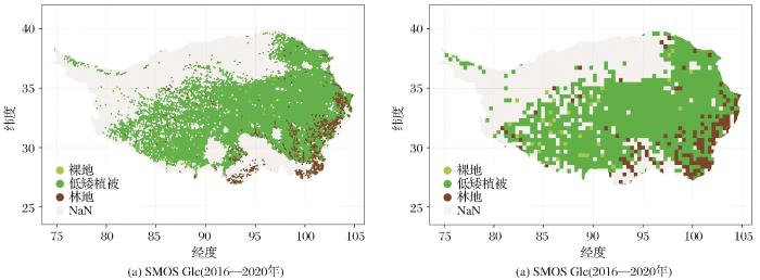
其中,草地(低矮植被)和森林(林地)在所属大类中的占比高于其他地类。各大类植被空间分布(图5)差异明显,低矮植被广泛分布于青藏高原大部分地区,林地和裸地零星分布在东南部。在C3S Global LC的地表分类基础上,在SMOS和SMAP各自的空间组织方式下,各种地类的占比相差并不明显,在空间分布上具有一致性。
(3)不同覆被条件下土壤水分与降水、蒸散发 的相关特征
图6
图6
青藏高原地区土壤水分与降水、蒸散发间偏相关系数空间分布图 审图号:2019(1819)
Fig.6
Spatial distribution of partial correlation coefficient between Soil Moisture, Precipitation and Evapotranspiration in Qinghai-Tibet Plateau
图7
图7
青藏高原地区不同地类下偏相关系数格点数目占比
Fig.7
Proportion of grid points of downward biased correlation coefficient of different land types in Qinghai Tibet Plateau
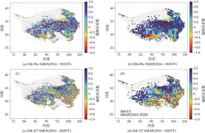
研究表明,在高原中东部土壤水分上升区,土壤水分与降水的相关性高于蒸散发,这表明该区域土壤水分的变化受降水量增加的影响较大。在高原东南部土壤水分上升区域,土壤水分与蒸散发呈负相关,与降水呈正相关但相关性较低,这表明该地区土壤水分的上升受蒸散发的下降影响高于降水。在研究区西部土壤水分下降区域,土壤水分与降水和蒸散发相关性均较高,结合该区域土壤水分消长趋势(图3),可以初步判定该地区土壤水分下降受降水量的减少影响更大。
对相关性数值进行分级(-1—-0.5、-0.5—0、0—0.5、0.5—1)后,分别对不同地类和不同相关性区间内的土壤水分与降水、蒸散发的相关性数值数目进行统计分析。结果表明,在低矮植被处,
综上所述,在青藏高原绝大部分区域,土壤水分的变化受降水影响较大。SMOS和SMAP所捕获的土壤水分在数值上与降水、蒸散发的相关性表现具有很好的一致性。
5 结 论
本文基于SMOS(2011—2020年)和SMAP(2016—2020年)卫星数据,对青藏高原土壤水分在季风及植被生长季的长消特征进行了研究,并结合GPCP降水、MOD16A2蒸散发和C3S Global LC地表覆被数据,初步就关键要素与土壤水分的耦合特征进行了探究,得到以下结论:
(1)青藏高原土壤水分在时间上呈现波动式上升趋势,在空间上呈现自东南向西北逐渐降低的特征。SMOS和SMAP均能捕获土壤水分的波动特征,在空间上反映出相似的分布特征。青藏高原土壤水分的增减变化在时序上与全球温度异常和厄尔尼诺、拉尼娜事件有一定的跟随性。
(2)青藏高原土壤水分在空间上呈现东部及东南部上升、西部下降的总体趋势,区内“干变干”、“湿变湿”特征明显。SMAP和SMOS对土壤水分长消特征的反映具有一致性,但前者对“趋湿”和“变干”的表现更为突出。
(3)青藏高原土壤水分的长消变化受降水、蒸散发和地表覆被等多方面影响,降水、蒸散发的增减组合决定了土壤水分的空间分布和时序变化;在地表覆被条件的控制下,土壤水分与降水的相关性较与蒸散发略强。
参考文献
Research on geomorphological regionalization of China
[J].
中国地貌区划新论
[J].
Progress on L-band microwave radiometry observation and soil moisture retrieval over the Tibetan Plateau
[J].
青藏高原L波段微波辐射观测与土壤水分反演研究进展
[J].
Debris-cover effect in the Tibetan Plateau and surroundings: A review
[J].
青藏高原及周边冰川区表碛影响研究进展
[J].
TPE international program: A program for coping with major future environmental challenges of The Third Pole Region
[J].
第三极环境(TPE)”国际计划——应对区域未来环境生态重大挑战问题的国际计划
[J].
Review of climate and cryospheric change in the Tibetan Plateau
[J].
Effect of the asian water tower over the Qinghai-Tibet Plateau and the characteristics of atmospheric water circulation (in Chinese)
[J].
青藏高原“亚洲水塔”效应和大气水分循环特征
[J].
years' climate change and its environmental impacts on the Qinghai-Xizang Plateau
[J].
青藏高原近60年来气候变化及其环境影响研究进展
[J].
Temporal and spatial differences and driving factors of evapotranspiration from terrestrial ecosystems of the Qinghai Province in the past 20 years
[J].
Asian water tower change and its impacts
[J].
“亚洲水塔”变化与影响
[J].
Responses of permafrost to climate change and their environmental significance, Qinghai-Tibet Plateau
[J].
A spatiotemporal continuous soil moisture dataset over the Tibet Plateau from 2002 to 2015
[J].
Precipitation recycling ratio and water vapor sources on the Tibetan Plateau
[J].
青藏高原降水再循环率与水汽来源辨析
[J].
Effect of energy and water circulation over Tibetan Plateau
[J].
青藏高原能量、水分循环影响效应
[J].
Hydrological modelling over the Tibetan Plateau: Current status and perspective
[J].
青藏高原水文模拟的现状及未来
[J].
Spatial variability in the seasonal distribution of precipitation on the Tibetan Plateau
[J].
青藏高原降水季节分配的空间变化特征
[J].
Climatic and associated cryospheric, biospheric, and hydrological changes on the Tibetan Plateau: A review
[J].
Research status and current hotspots on the human impact on natural reserves in the Qinghai-Tibetan Plateau
[J].
青藏高原自然保护区人类活动及其影响研究现状与热点
[J].
Study progresses of the Tibet Plateau climate system change and mechanism of its impact on East Asia
[J].
青藏高原气候系统变化及其对东亚区域的影响与机制研究进展
[J].
Connotation and evaluation of high-quality development in counties of the Qinghai-Tibet Plateau
[J].
区域高质量发展的内涵与评价体系探索——以青藏高原县域单元为例
[J].
Spatial and temporal differences in alpine meadow, alpine steppe and all vegetation of the Qinghai-Tibetan Plateau and their responses to climate change
[J].
Coupling effects of different land preparation and vegetation on soil moisture characteristics in a Semi-Arid Loess Hilly Region
[J].
黄土丘陵区坡面整地和植被耦合下的土壤水分特征
[J].
Differential response to rainfall of soil moisture infiltration in permafrost and seasonally frozen ground in Kangqiong Small Basin on the Qinghai-Tibet Plateau
[J].
Long-Distance atmospheric moisture dominates water budget in permafrost regions of the Central Qinghai-Tibet Plateau
[J].
Impact of soil organic matter content on soil moisture and temperature at different depths in the Central Qinghai-Xizang Plateau
[J].
青藏高原中部土壤有机质含量对不同深度土壤温湿度的影响研究
[J].
Responses of root functional traits to experimental warming in the alpine meadow with different soil moisture in the permafrost region of the Qinghai-Tibet Plateau
[J].
青藏高原多年冻土区不同水分条件的高寒草甸根系功能性状对增温的响应
[J].
Soil moisture variations in response to precipitation across different vegetation types on the Northeastern Qinghai-Tibet Plateau
[J].
Effect of organic compounds content and types on soil water retention dapacity
[J].
有机物质类型与含量对土壤持水性能的影响
[J].
From Tibetan Plateau to Third Pole and Pan-Third Pole
[J].
从青藏高原到第三极和泛第三极
[J].
A comprehensive study of water-ecosystem-human activities reveals unbalancing asian water tower and accompanying potential risks
[J].
青藏高原水—生态—人类活动考察研究揭示“亚洲水塔”的失衡及其各种潜在风险
[J].
Analysis on the applicability of reanalysis soil temperature and moisture datasets over Qinghai-Tibetan Plateau
[J].
再分析土壤温湿度资料在青藏高原地区适用性的分析
[J].
The review of the observation experiments on land-atmosphere interaction progress on the Qinghai-Xizang(Tibetan)Plateau
[J].
青藏高原多圈层地气相互作用过程研究进展和回顾
[J].
A Multiscale soil moisture and freeze-thaw monitoring network on the Third Pole
[J].
Comparative evaluation of SMAP,CCI, CLDAS soil moisture products in typical region of Qinghai-Tibet Plateau
[J].
SMAP、CCI和CLDAS土壤湿度产品在青藏高原典型区域的比较验证
[J].
Applicability of soil temperature and moisture in several datasets over Qinghai-Xizang Plateau
[J].
多套土壤温湿度资料在青藏高原的适用性
[J].
Spatial and temporal distribution of soil moisture over the Tibetan Plateau during 2009-2010
[J].
2009-2010年青藏高原土壤湿度的时空分布特征
[J].
Temporal and spatial changes of soil moisture and its response to temperature and precipitation over the Tibetan Plateau
[J].
A Study on the assessment of multi-source satellite soil moisture products and reanalysis data for the Tibetan Plateau
[J].
The 20-year spatiotemporal trends of remotely sensed soil moisture and vegetation and their response to climate change over the Third Pole
[J].
Advances in agricultural drought monitoring based on soil moisture
[J].
基于土壤水分的农业干旱监测研究进展
[J].
Moisture derived from microwave remote sensing in Northeast China
[J].
利用微波遥感土壤水分产品监测东北地区春涝范围和程度
[J].
Drought monitoring with Soil Moisture Active Passive (SMAP) Measurements
[J].
A global near-real-time soil moisture index monitor for food security using integrated SMOS and SMAP
[J].
Assessment of SMAP and SMOS soil moisture products using triple collocation method over Inner Mongolia
[J].
Evaluation of SMAP, SMOS-IC, FY3B, JAXA, and LPRM soil moisture products over the Qinghai-Tibet Plateau and its surrounding areas
[J].
Triple collocation-based assessment of satellite soil moisture products with In situ measurements in China: Understanding the Error Sources
[J].
Evaluation of the SMOS and SMAP soil moisture products under different vegetation types against two sparse in situ networks over arid mountainous watersheds, Northwest China
[J].
Comparative eva-luation and difference analysis of SMOS and SMAP satellite remote sensing soil moisture products
[J].DOI:10.13471/j.cnki.acta.snus.2021D049
SMOS和SMAP卫星土壤水分产品的对比评价与差异分析
[J].
Adaptability evaluation of soil moisture products in the Hebei Plain
[J].
多源土壤水分产品在河北平原的适用性评价
[J].
Evaluation of the SMOS and SMAP soil moisture products under different vegetation types against two sparse in situ networks over arid mountainous watersheds,Northwest China
[J].
Assessment of the SMAP passive soil moisture product
[J].
A comparative study of the SMAP passive soil moisture product with existing satellite-based soil moisture products
[J].
The international soil moisture network: A data hosting facility for global in situ soil moisture measurements
[J].
The Version-2 Global Precipitation Climatology Project (GPCP) monthly precipitation analysis(1979-Present)
[J].
The Global Precipitation Climat-ology Project (GPCP) Monthly Analysis (New Version 2.3) and a Review of 2017 Global Precipitation
[J].
Spatio-temporal variations of evapotranspiration in Poyang Lake Basin using MOD16 products
[J].
基于MOD16产品的鄱阳湖流域地表蒸散量时空分布特征
[J].
Validation of evapotranspiration and it's long-term trends in the Yellow River source region
[J].
A study on the assessment of multi-source satellite soil moisture products and reanalysis data for the Tibetan Plateau
[J].
Climatic regionalization of the Qinghai-Xizang Plateau
[J].
青藏高原气候区划
[J].
The temporal-spatial variations of soil moisture over the Tibetan Plateau during 1980-2012
[J].
1980-2012年青藏高原土壤湿度时空演变特征
[J].
Variation of soil moisture and its relation with precipitation of permafrost and seasonally frozen soil regions on the Qinghai-Tibet Plateau
[J].
青藏高原多年冻土和季节性冻土区土壤水分变化及其与降水的关系
[J].
SMAP L-band microwave radiometer: RFI mitigation prelaunch analysis and first year on-orbit observations
[J].
Assessment and error analysis of satellite soil moisture products over the Third Pole
[J].


